IMAGES TAKEN NEAR TO
High House Lane, WOLVERHAMPTON, WV7 3JL
Introduction
This page details the photographs taken nearby to High House Lane, WV7 3JL by members of the Geograph project.
The Geograph project started in 2005 with the aim of publishing, organising and preserving representative images for every square kilometre of Great Britain, Ireland and the Isle of Man.

There are currently over 7.5m images from over14,400 individuals and you can help contribute to the project by visiting https://www.geograph.org.uk
Image Map
Images are licensed for reuse under creativecommons.org/licenses/by-sa/2.0
Notes
- Clicking on the map will re-center to the selected point.
- The higher the marker number, the further away the image location is from the centre of the postcode.
Image Listing (11 Images Found)
Images are licensed for reuse under creativecommons.org/licenses/by-sa/2.0
Image
Details
Distance
1
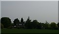
Houses on High House Lane, Albrighton
Image: © Christopher Hilton
Taken: 9 Jun 2016
0.00 miles
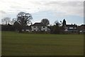
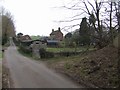
3
Field and house on High House Lane Albrighton
Image: © Roy Hughes
Taken: 14 Aug 2021
0.04 miles
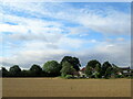
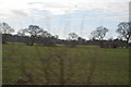
4
House and field off High House Lane, Albrighton
Image: © Christopher Hilton
Taken: 9 Jun 2016
0.05 miles
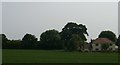
6
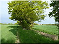
Fields and footpath near High House Farm
Image: © Richard Law
Taken: 19 May 2010
0.13 miles

9
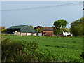
Millfield Farm
Typical farm in a quiet rural area next to A41 embankment.
Image: © John M
Taken: 24 Mar 2007
0.21 miles
10
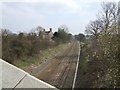
Shrewsbury to Wolverhampton Line
Once upon a time express trains used to run from Aberystwyth through to Birmingham and London. Now the main service is the commuter line to Telford and Shrewsbury.
Beamish Farm can be seen on the left.
Image: © John M
Taken: 24 Mar 2007
0.24 miles