IMAGES TAKEN NEAR TO
Bowling Green Lane, WOLVERHAMPTON, WV7 3HL
Introduction
This page details the photographs taken nearby to Bowling Green Lane, WV7 3HL by members of the Geograph project.
The Geograph project started in 2005 with the aim of publishing, organising and preserving representative images for every square kilometre of Great Britain, Ireland and the Isle of Man.

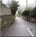
There are currently over 7.5m images from over14,400 individuals and you can help contribute to the project by visiting https://www.geograph.org.uk
Image Map
Images are licensed for reuse under creativecommons.org/licenses/by-sa/2.0
Notes
- Clicking on the map will re-center to the selected point.
- The higher the marker number, the further away the image location is from the centre of the postcode.
Image Listing (43 Images Found)
Images are licensed for reuse under creativecommons.org/licenses/by-sa/2.0
Image
Details
Distance
1
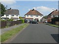
St Cuthbert's Crescent meets Bowling Green Lane
Image: © Peter Whatley
Taken: 8 Jun 2013
0.07 miles
2
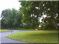
Bowling Green Lane Island
The view in Albrighton.
Image: © Gordon Griffiths
Taken: 20 Jun 2018
0.10 miles
3
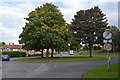
Roundabout at the top of Bowling Green Lane
Fntering the urban area.
Image: © John M
Taken: 8 Oct 2013
0.11 miles
4
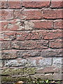
OS benchmark - Albrighton, Bowling Green Lane
The rather badly damaged remains of an OS cutmark in the brickwork of a building on the north side of Bowling Green Lane; originally levelled in 1959 at 93.632m above Ordnance Datum Newlyn.
Image: © Richard Law
Taken: 11 May 2014
0.17 miles
5

Grange Park, Albrighton
Newport Road end of a long cul-de-sac named Grange Park.
Image: © Jaggery
Taken: 1 Dec 2015
0.18 miles
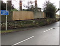
6
Bowling Green Lane, Albrighton
Viewed from the corner of Newport Road.
Image: © Jaggery
Taken: 1 Dec 2015
0.19 miles
7
The Shrewsbury Arms, Albrighton
A long-established pub on the old A41 road through Albrighton; there appear to be some refurbishments taking place in mid 2009, and it's to be hoped the place will re-open afterwards.
Image: © Richard Law
Taken: 24 Jul 2009
0.19 miles
8
Weight limit ahead, Bowling Green Lane, Albrighton
The sign facing Newport Road shows a 7.5 tonnes weight limit on Bowling Green Lane 500 yards ahead.
Image: © Jaggery
Taken: 1 Dec 2015
0.20 miles
9
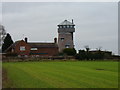
The Old Windmill, Albrighton
A former 18th century tower windmill, now converted to a dwelling. The internal mill machinery has gone, as have the sails, and the 'observation room' at the top is an early 20th century addition by an owner who wanted to be able to see the Shropshire Hills. Grade II listed https://britishlistedbuildings.co.uk/101053693-the-old-windmill-albrighton#.Xmjewaj7RPY & https://historicengland.org.uk/listing/the-list/list-entry/1053693 in 1984.
Image: © Richard Law
Taken: 31 Dec 2019
0.20 miles
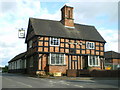
10
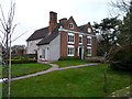
The Elms, Albrighton
Thought to be late 16th or early 17th century, but obviously much altered and extended over the years. The two front gables probably represent the oldest parts of the house, and are timber-framed with a brick facing. The whole building attracted a Grade II listing https://britishlistedbuildings.co.uk/101053692-the-elms-albrighton#.Xmjgcqj7RPY & https://historicengland.org.uk/listing/the-list/list-entry/1053692 in 1984.
Image: © Richard Law
Taken: 31 Dec 2019
0.20 miles