IMAGES TAKEN NEAR TO
Cotswold Drive, WOLVERHAMPTON, WV7 3DQ
Introduction
This page details the photographs taken nearby to Cotswold Drive, WV7 3DQ by members of the Geograph project.
The Geograph project started in 2005 with the aim of publishing, organising and preserving representative images for every square kilometre of Great Britain, Ireland and the Isle of Man.

There are currently over 7.5m images from over14,400 individuals and you can help contribute to the project by visiting https://www.geograph.org.uk
Image Map
Images are licensed for reuse under creativecommons.org/licenses/by-sa/2.0
Notes
- Clicking on the map will re-center to the selected point.
- The higher the marker number, the further away the image location is from the centre of the postcode.
Image Listing (142 Images Found)
Images are licensed for reuse under creativecommons.org/licenses/by-sa/2.0
Image
Details
Distance

2
OS benchmark - Albrighton, wall on Station Road
An OS cutmark on a low roadside wall outside one of the houses on the south side of the road; originally levelled at 95.293m above Ordnance Datum Newlyn.
Image: © Richard Law
Taken: 24 May 2015
0.07 miles
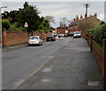
3
Eastern end of Meadow Road, Albrighton
From Shaw Lane looking along Meadow Road towards a 90 degree bend in the road about 170 metres ahead.
Image: © Jaggery
Taken: 1 Dec 2015
0.10 miles
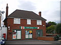
4
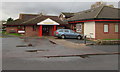
Albrighton Medical Practice
Set back from the west side of Shaw Lane. The practice's website states that the earliest recorded medical practitioner in Albrighton was an unnamed surgeon apothecary who was recorded working in the village in 1790. This surgery was built in 1963 and extensively modernised and extended in 1992 and 1996. Albrighton village population has grown from c1200 in 1930 to more than 4000. In that time, the medical practice has expanded from just one nurse and doctor to 6 doctors, 26 employed staff and 12 attached staff serving a practice list of 8900. The practice area covers c80 square miles of Shropshire and Staffordshire countryside.
Image: © Jaggery
Taken: 1 Dec 2015
0.10 miles
5
Trees, houses and postbox, Station Road, Albrighton
Viewed from the corner of Albrighton railway station access road. http://www.geograph.org.uk/photo/4755321 The postbox is Victorian. http://www.geograph.org.uk/photo/4755508
Image: © Jaggery
Taken: 1 Dec 2015
0.10 miles
6
Warning sign - school ahead, Albrighton
The sign is alongside Shaw Lane on the approach to this http://www.geograph.org.uk/photo/4755613 entrance to St Mary's C of E Primary School.
Image: © Jaggery
Taken: 1 Dec 2015
0.12 miles
7
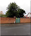
Shaw Lane electricity substation, Albrighton
The padlocked green door is the entrance to the Western Power Distribution
electricity substation on the west side of Shaw Lane. Its identifier is SHAW LANE S/S No. 962.
Image: © Jaggery
Taken: 1 Dec 2015
0.12 miles
9
Shaw Lane, Albrighton
On the south side of Station Road.
Image: © Jaggery
Taken: 1 Dec 2015
0.13 miles
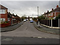
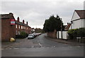
10
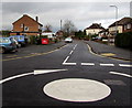
Meadow Road, Albrighton
Meadow Road is on the north side of the mini-roundabout at the High Street junction.
Image: © Jaggery
Taken: 1 Dec 2015
0.13 miles