IMAGES TAKEN NEAR TO
Woodhouse Lane, WOLVERHAMPTON, WV7 3BZ
Introduction
This page details the photographs taken nearby to Woodhouse Lane, WV7 3BZ by members of the Geograph project.
The Geograph project started in 2005 with the aim of publishing, organising and preserving representative images for every square kilometre of Great Britain, Ireland and the Isle of Man.

There are currently over 7.5m images from over14,400 individuals and you can help contribute to the project by visiting https://www.geograph.org.uk
Image Map
Images are licensed for reuse under creativecommons.org/licenses/by-sa/2.0
Notes
- Clicking on the map will re-center to the selected point.
- The higher the marker number, the further away the image location is from the centre of the postcode.
Image Listing (14 Images Found)
Images are licensed for reuse under creativecommons.org/licenses/by-sa/2.0
Image
Details
Distance
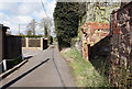
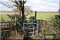
3

Footpath to Albrighton
New fingerpost next to the stile on this well used rural footpath.
Image: © John M
Taken: 24 Mar 2007
0.14 miles
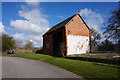
5
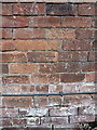
OS benchmark - Boningale, Parkside Farm
An OS cutmark on the wall of the large barn at Parkside; originally levelled at 88.773m above Ordnance Datum Newlyn.
Image: © Richard Law
Taken: 22 Aug 2017
0.14 miles
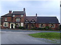
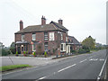
8
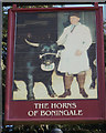
Horns of Boningale, Boningale
http://www.geograph.org.uk/photo/4898087
Image: © Ian S
Taken: 31 Mar 2016
0.22 miles