IMAGES TAKEN NEAR TO
Green Lane, WOLVERHAMPTON, WV7 3BP
Introduction
This page details the photographs taken nearby to Green Lane, WV7 3BP by members of the Geograph project.
The Geograph project started in 2005 with the aim of publishing, organising and preserving representative images for every square kilometre of Great Britain, Ireland and the Isle of Man.

There are currently over 7.5m images from over14,400 individuals and you can help contribute to the project by visiting https://www.geograph.org.uk
Image Map
Images are licensed for reuse under creativecommons.org/licenses/by-sa/2.0
Notes
- Clicking on the map will re-center to the selected point.
- The higher the marker number, the further away the image location is from the centre of the postcode.
Image Listing (5 Images Found)
Images are licensed for reuse under creativecommons.org/licenses/by-sa/2.0
Image
Details
Distance
3
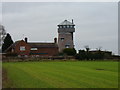
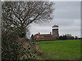
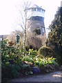
The Old Windmill, Albrighton
A former 18th century tower windmill, now converted to a dwelling. The internal mill machinery has gone, as have the sails, and the 'observation room' at the top is an early 20th century addition by an owner who wanted to be able to see the Shropshire Hills. Grade II listed https://britishlistedbuildings.co.uk/101053693-the-old-windmill-albrighton#.Xmjewaj7RPY & https://historicengland.org.uk/listing/the-list/list-entry/1053693 in 1984.
Image: © Richard Law
Taken: 31 Dec 2019
0.23 miles
4
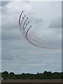
Red Arrows display - Cosford Airshow June 2012
One of many superbly executed runs by the RAF's highly drilled display team, unfortunately on a rather gloomy day for photography.
Image: © Richard Law
Taken: 17 Jun 2012
0.25 miles
5
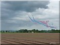
Red Arrows on a low-level run towards the airfield
Tracer smoke marks the flightpath of the displaying planes as they barrel in towards the crowds at the 2012 Cosford Airshow, from a southeasterly direction.
Image: © Richard Law
Taken: 17 Jun 2012
0.25 miles