IMAGES TAKEN NEAR TO
County Lane, WOLVERHAMPTON, WV7 3BL
Introduction
This page details the photographs taken nearby to County Lane, WV7 3BL by members of the Geograph project.
The Geograph project started in 2005 with the aim of publishing, organising and preserving representative images for every square kilometre of Great Britain, Ireland and the Isle of Man.

There are currently over 7.5m images from over14,400 individuals and you can help contribute to the project by visiting https://www.geograph.org.uk
Image Map
Images are licensed for reuse under creativecommons.org/licenses/by-sa/2.0
Notes
- Clicking on the map will re-center to the selected point.
- The higher the marker number, the further away the image location is from the centre of the postcode.
Image Listing (7 Images Found)
Images are licensed for reuse under creativecommons.org/licenses/by-sa/2.0
Image
Details
Distance
1
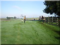
Runners coming into Hawks Well cottage garden
Part of the 2014 Pattingham Bells 7-mile cross country race; here, after a footpath section from Boningale, the route drops back into the woods of the Scotts Bank plantation behind me.
Image: © Richard Law
Taken: 12 Oct 2014
0.03 miles
2
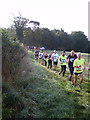
2014 Pattingham Bells cross country race
Emerging from The Beeches spinney, on a cool but bright October morning. The race started life 25 years ago to help raise money for the restoration of the Pattingham church bells, and having achieved that aim, is now a popular event on the local running scene. It's great fun, to boot.
Image: © Richard Law
Taken: 12 Oct 2014
0.05 miles
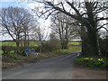
4
Lane and footpath south of Kingswood, Shropshire
The public footpath leads down to the left, towards Boningale; Westbeech Road goes north-north-east towards Kingswood.
Image: © Roger Kidd
Taken: 8 Apr 2007
0.15 miles
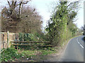
5
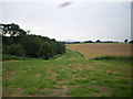
Along the county boundary
With the fields of Shropshire on the right, and woodland Staffordshire on the left. The Wrekin is just about visible on the horizon.
Image: © Richard Law
Taken: 23 Jul 2008
0.17 miles
6
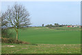
Cereal Crop Field near Pepperhill, Shropshire
Open and undulating arable land. Upper Pepperhill Farm can be seen on the sky-line, to the right.
Image: © Roger Kidd
Taken: 8 Apr 2007
0.19 miles
7
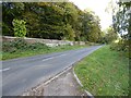
Country road to the north of Pattingham
Country road to the north of Pattingham passing along side the eastern boundary wall of High Park.
Image: © Philip Halling
Taken: 19 Oct 2016
0.24 miles