IMAGES TAKEN NEAR TO
Blue House Lane, WOLVERHAMPTON, WV7 3AE
Introduction
This page details the photographs taken nearby to Blue House Lane, WV7 3AE by members of the Geograph project.
The Geograph project started in 2005 with the aim of publishing, organising and preserving representative images for every square kilometre of Great Britain, Ireland and the Isle of Man.

There are currently over 7.5m images from over14,400 individuals and you can help contribute to the project by visiting https://www.geograph.org.uk
Image Map
Images are licensed for reuse under creativecommons.org/licenses/by-sa/2.0
Notes
- Clicking on the map will re-center to the selected point.
- The higher the marker number, the further away the image location is from the centre of the postcode.
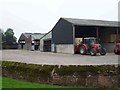
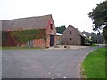
Image Listing (12 Images Found)
Images are licensed for reuse under creativecommons.org/licenses/by-sa/2.0
Image
Details
Distance
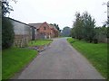
1
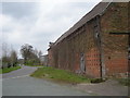
Farm buildings and the lane at Humphraston Hall
Image: © Row17
Taken: 18 Apr 2008
0.07 miles
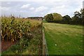
3
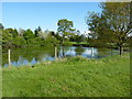
Pond near Humphreston Hall
Many years ago (OK, about 20) I knew the owner of the fishing rights on this pool. He allowed a local angling club (with the agreement of the Severn Trent Water Authority's scientist) to remove some small common carp from here, and relocate them into a stretch of the old canal at Newport. Within a couple of years, they'd grown into 8-10lb fish, and were breaking the tackle of just about anyone fishing for them. It seemed a good idea at the time!
Image: © Richard Law
Taken: 16 May 2010
0.10 miles
6
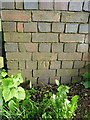
OS benchmark - bridge west of Humphreston Hall
An OS cutmark on the bridge on Blue House Lane, where it crosses a small stream; originally levelled at 92.745m above Ordnance Datum Newlyn.
Image: © Richard Law
Taken: 24 May 2015
0.17 miles
8
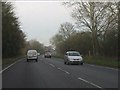
A41 Albrighton bypass at the footpath to Humprheston
Note the short-armed sign on the right of the silver car.
Image: © Peter Whatley
Taken: 17 Jan 2012
0.21 miles
10
Albrighton Moat Project
Not open at weekends.
Image: © John M
Taken: 20 Oct 2013
0.23 miles