IMAGES TAKEN NEAR TO
Knights Avenue, WOLVERHAMPTON, WV6 9QA
Introduction
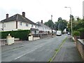
This page details the photographs taken nearby to Knights Avenue, WV6 9QA by members of the Geograph project.
The Geograph project started in 2005 with the aim of publishing, organising and preserving representative images for every square kilometre of Great Britain, Ireland and the Isle of Man.

There are currently over 7.5m images from over14,400 individuals and you can help contribute to the project by visiting https://www.geograph.org.uk
Image Map
Images are licensed for reuse under creativecommons.org/licenses/by-sa/2.0
Notes
- Clicking on the map will re-center to the selected point.
- The higher the marker number, the further away the image location is from the centre of the postcode.
Image Listing (47 Images Found)
Images are licensed for reuse under creativecommons.org/licenses/by-sa/2.0
Image
Details
Distance
8
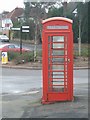
K6 Phonebox
Locally listed telephone box at the corner of Blackburn Avenue and Codsall Road. An unusual survivor in an urban location. This example has the cable guide on the roof.
Removed by April 2015. Local listing does not seem to offer any protection to buildings in the city.
Image: © John M
Taken: 30 Dec 2006
0.08 miles