IMAGES TAKEN NEAR TO
Lowlands Avenue, WOLVERHAMPTON, WV6 9PT
Introduction
This page details the photographs taken nearby to Lowlands Avenue, WV6 9PT by members of the Geograph project.
The Geograph project started in 2005 with the aim of publishing, organising and preserving representative images for every square kilometre of Great Britain, Ireland and the Isle of Man.

There are currently over 7.5m images from over14,400 individuals and you can help contribute to the project by visiting https://www.geograph.org.uk
Image Map
Images are licensed for reuse under creativecommons.org/licenses/by-sa/2.0
Notes
- Clicking on the map will re-center to the selected point.
- The higher the marker number, the further away the image location is from the centre of the postcode.
Image Listing (85 Images Found)
Images are licensed for reuse under creativecommons.org/licenses/by-sa/2.0
Image
Details
Distance
1
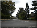
West end of Lowlands Avenue, Aldersley
Seen from Lower Street.
Image: © Richard Vince
Taken: 30 Sep 2017
0.02 miles
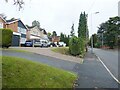
2
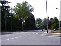
Lower Street
The view from Malthouse Lane.
Image: © Gordon Griffiths
Taken: 1 Jul 2009
0.02 miles
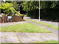
5
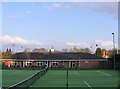
Tennis Club View
The view of Albert Lawn Tennis Club off Aldersley Road in Claregate, Wolverhampton.
Image: © Gordon Griffiths
Taken: 14 Apr 2018
0.07 miles
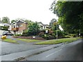
9
Redacres View
The view along Malthouse Lane, Claregate.
Image: © Gordon Griffiths
Taken: 1 Jul 2009
0.09 miles
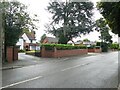
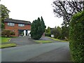
10
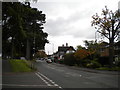
South end of Codsall Road, Claregate
Seen from the north end of Lower Street.
Image: © Richard Vince
Taken: 30 Sep 2017
0.10 miles