IMAGES TAKEN NEAR TO
Grotto Lane, WOLVERHAMPTON, WV6 9LP
Introduction
This page details the photographs taken nearby to Grotto Lane, WV6 9LP by members of the Geograph project.
The Geograph project started in 2005 with the aim of publishing, organising and preserving representative images for every square kilometre of Great Britain, Ireland and the Isle of Man.

There are currently over 7.5m images from over14,400 individuals and you can help contribute to the project by visiting https://www.geograph.org.uk
Image Map
Images are licensed for reuse under creativecommons.org/licenses/by-sa/2.0
Notes
- Clicking on the map will re-center to the selected point.
- The higher the marker number, the further away the image location is from the centre of the postcode.
Image Listing (107 Images Found)
Images are licensed for reuse under creativecommons.org/licenses/by-sa/2.0
Image
Details
Distance
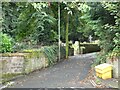
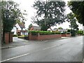
6
Grotto Lane, Tettenhall
Seen from Lower Street.
Image: © Richard Vince
Taken: 30 Sep 2017
0.06 miles
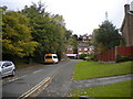
7
Grotto Lane, Tettenhall
Once a very narrow lane, this steep cul-de-sac beside the churchyard leads up to a footpath to Upper Tettenhall.There are openings cut into the sandstone rock at the top of the road but were these the grottos?
Image: © John M
Taken: 21 Apr 2007
0.06 miles
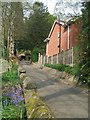
8
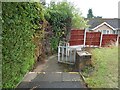
Footpath to Clifton Road, Tettenhall
The footpath leads up from St Michaels Church towards Upper Tettenhall.
Image: © John M
Taken: 21 Apr 2007
0.07 miles
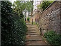
10

Church Steps
The view of the path in Tettenhall from St Michael and All Angels Church.
Image: © Gordon Griffiths
Taken: 20 Jan 2022
0.07 miles