IMAGES TAKEN NEAR TO
Green Lane, WOLVERHAMPTON, WV6 9HL
Introduction
This page details the photographs taken nearby to Green Lane, WV6 9HL by members of the Geograph project.
The Geograph project started in 2005 with the aim of publishing, organising and preserving representative images for every square kilometre of Great Britain, Ireland and the Isle of Man.

There are currently over 7.5m images from over14,400 individuals and you can help contribute to the project by visiting https://www.geograph.org.uk
Image Map
Images are licensed for reuse under creativecommons.org/licenses/by-sa/2.0
Notes
- Clicking on the map will re-center to the selected point.
- The higher the marker number, the further away the image location is from the centre of the postcode.
Image Listing (49 Images Found)
Images are licensed for reuse under creativecommons.org/licenses/by-sa/2.0
Image
Details
Distance
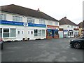
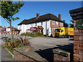
9
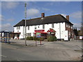
The Pilot - Green Lane
Interwar public house designed by local architect Richard Twentyman.
Image: © John M
Taken: 6 Apr 2013
0.07 miles
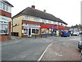
10
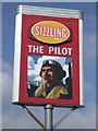
Modern pub sign at the Pilot PH
The pub draws its name from the nearby Wolverhampton Airport.
Image: © John M
Taken: 6 Apr 2013
0.07 miles