IMAGES TAKEN NEAR TO
Danescourt Road, WOLVERHAMPTON, WV6 9BH
Introduction
This page details the photographs taken nearby to Danescourt Road, WV6 9BH by members of the Geograph project.
The Geograph project started in 2005 with the aim of publishing, organising and preserving representative images for every square kilometre of Great Britain, Ireland and the Isle of Man.

There are currently over 7.5m images from over14,400 individuals and you can help contribute to the project by visiting https://www.geograph.org.uk
Image Map
Images are licensed for reuse under creativecommons.org/licenses/by-sa/2.0
Notes
- Clicking on the map will re-center to the selected point.
- The higher the marker number, the further away the image location is from the centre of the postcode.
Image Listing (16 Images Found)
Images are licensed for reuse under creativecommons.org/licenses/by-sa/2.0
Image
Details
Distance
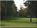
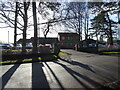
1

South Staffs Golf Course
The view off the path from Danescourt Road of the Golf Course in Tettenhall, Wolverhampton.
Image: © Gordon Griffiths
Taken: 20 Jan 2022
0.12 miles
2
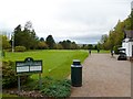
Tettenhall, golf club
South Staffs Golf Club, looking from tee no.1, with the shop to right. http://www.southstaffordshiregolfclub.co.uk/
Image: © Mike Faherty
Taken: 12 Oct 2011
0.13 miles
3

Tettenhall, golf clubhouse
At South Staffs Golf Club: http://www.southstaffordshiregolfclub.co.uk/The_Clubhouse
Image: © Mike Faherty
Taken: 12 Oct 2011
0.14 miles
4
Hedged Path
The view off the path from Danescourt Road on the Golf Course in Tettenhall, Wolverhampton.
Image: © Gordon Griffiths
Taken: 25 Feb 2022
0.14 miles
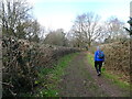
5

South Staffs Path
The view of the path off Danescourt Road by the Golf Course in Tettenhall, Wolverhampton.
Image: © Gordon Griffiths
Taken: 20 Jan 2022
0.16 miles
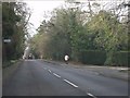
6

South Staffs Golf Club
The view from Danescourt Road Tettenhall, Wolverhampton.
Image: © Gordon Griffiths
Taken: 20 Jan 2022
0.16 miles
8
Wolverhampton Cricket Club
The view from Danescourt Road Tettenhall, Wolverhampton.
Image: © Gordon Griffiths
Taken: 20 Jan 2022
0.19 miles
9
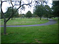
Danescourt Cemetery, Tettenhall
The 1:50,000 map appears to mark the cemetery in the next square east, which to be truthful is where most of it does really lie. But it also stretches into SJ8700, so this seems a valid photo.
Image: © Richard Law
Taken: 25 Sep 2009
0.20 miles