IMAGES TAKEN NEAR TO
Danescourt Road, WOLVERHAMPTON, WV6 9BE
Introduction
This page details the photographs taken nearby to Danescourt Road, WV6 9BE by members of the Geograph project.
The Geograph project started in 2005 with the aim of publishing, organising and preserving representative images for every square kilometre of Great Britain, Ireland and the Isle of Man.

There are currently over 7.5m images from over14,400 individuals and you can help contribute to the project by visiting https://www.geograph.org.uk
Image Map
Images are licensed for reuse under creativecommons.org/licenses/by-sa/2.0
Notes
- Clicking on the map will re-center to the selected point.
- The higher the marker number, the further away the image location is from the centre of the postcode.
Image Listing (79 Images Found)
Images are licensed for reuse under creativecommons.org/licenses/by-sa/2.0
Image
Details
Distance
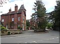
1
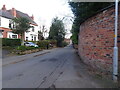
Danescourt Road
The view along Danescourt Road in Tettenhall, Wolverhampton.
Image: © Gordon Griffiths
Taken: 25 Feb 2022
0.02 miles
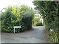
4
Tettenhall Alley
The view off Danescourt Road in Tettenhall, Wolverhampton.
Image: © Gordon Griffiths
Taken: 6 May 2021
0.07 miles
6
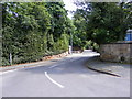
Stockwell Road
The view from the junction with Danescourt Road, Tettenhall.
Image: © Gordon Griffiths
Taken: 1 Jul 2009
0.08 miles
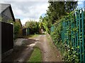
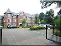
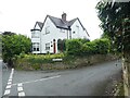
7
Tettenhall House
The view from Danescourt Road in Tettenhall, Wolverhampton.
Image: © Gordon Griffiths
Taken: 6 May 2021
0.08 miles
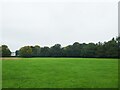
8
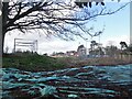
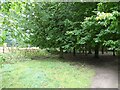
Cricket Pitch
The view of Wolverhampton Cricket Club off Danescourt Road Tettenhall, Wolverhampton.
Image: © Gordon Griffiths
Taken: 25 Feb 2022
0.08 miles
10
Junction of Stockwell Road and Church Hill Road
Image: © ElfExplorer
Taken: 3 Sep 2024
0.10 miles