IMAGES TAKEN NEAR TO
Clifton Road, WOLVERHAMPTON, WV6 9AP
Introduction
This page details the photographs taken nearby to Clifton Road, WV6 9AP by members of the Geograph project.
The Geograph project started in 2005 with the aim of publishing, organising and preserving representative images for every square kilometre of Great Britain, Ireland and the Isle of Man.

There are currently over 7.5m images from over14,400 individuals and you can help contribute to the project by visiting https://www.geograph.org.uk
Image Map
Images are licensed for reuse under creativecommons.org/licenses/by-sa/2.0
Notes
- Clicking on the map will re-center to the selected point.
- The higher the marker number, the further away the image location is from the centre of the postcode.
Image Listing (156 Images Found)
Images are licensed for reuse under creativecommons.org/licenses/by-sa/2.0
Image
Details
Distance
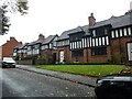
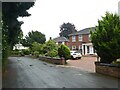
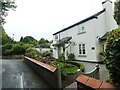
2
Substantial 1820s properties in Clifton Road
This area would have been developed after the new cutting was constructed for the turnpike at 'The Rock'on the Holyhead road.
Image: © John M
Taken: 21 Apr 2007
0.01 miles
5
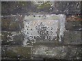
Old Milestone by the A41, The Rock, Tettenhall, Wolverhampton Parish
Carved stone post by the A41, in parish of WOLVERHAMPTON (WOLVERHAMPTON District), The Rock, Tettenhall, in sandstone wall between Old Hill and Upper Green, on South side of road. Erected by an unknown authority in the 19th century.
Inscription reads:-
SALOP 28
WHAMPTON
2 MILES.
L(O)NDON 12(8).
Wolverhampton and Walsall HER listed. HER Number: 14002
https://www.heritagegateway.org.uk/Gateway/Results_Single.aspx?uid=MBL5872&resourceID=1025
Milestone Society National ID: ST_WVSR02.
Image: © M Faherty
Taken: 30 Jun 2013
0.06 miles
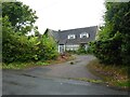
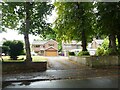
6
The Rock Cutting, Tettenhall
The rock cutting on the Holyhead road was completed in 1823 and bypassed the steep coach road up Old Hill Image
There appears to have been some disagreement on the design with the engineer Thomas Telford and this solution with a major cutting and embankments was pursued by the local turnpike trustees.
For more details see
http://www.localhistory.scit.wlv.ac.uk/listed/localist/TheRock.htm
Image: © John M
Taken: 21 Apr 2007
0.07 miles
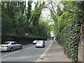
8

The Rock
The view of the Cutting through a sandstone ridge on A41 in Tettenhall. The cutting was built by the Wolverhampton Turnpike Trust in 1823.
Image: © Gordon Griffiths
Taken: 31 Aug 2022
0.07 miles