IMAGES TAKEN NEAR TO
Lower Street, WOLVERHAMPTON, WV6 9AB
Introduction
This page details the photographs taken nearby to Lower Street, WV6 9AB by members of the Geograph project.
The Geograph project started in 2005 with the aim of publishing, organising and preserving representative images for every square kilometre of Great Britain, Ireland and the Isle of Man.

There are currently over 7.5m images from over14,400 individuals and you can help contribute to the project by visiting https://www.geograph.org.uk
Image Map
Images are licensed for reuse under creativecommons.org/licenses/by-sa/2.0
Notes
- Clicking on the map will re-center to the selected point.
- The higher the marker number, the further away the image location is from the centre of the postcode.
Image Listing (194 Images Found)
Images are licensed for reuse under creativecommons.org/licenses/by-sa/2.0
Image
Details
Distance
1
St Michael's Court
The view near Lower Green Tettenhall, Wolverhampton.
Image: © Gordon Griffiths
Taken: 20 Jan 2022
0.04 miles
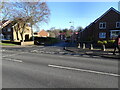
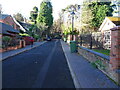
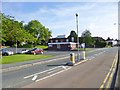
2
Lower Street Island
The view by Lower Green Tettenhall, Wolverhampton.
Image: © Gordon Griffiths
Taken: 20 Jan 2022
0.04 miles
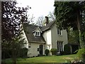
3
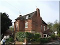
The Old Farmhouse on Church Walk, Tettenhall
A late 17th or early 18th century farmhouse. For many years there was the well known Nicholl's butchers shop attached to this building. This is a locally listed building.
Image: © John M
Taken: 21 Apr 2007
0.04 miles
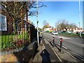
4
Lower Street, Tettenhall
The Swan Hotel lies below St Michaels Church. The road is a well used circular route to avoid the city centre.
Image: © John M
Taken: 21 Apr 2007
0.05 miles
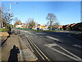
5
Church Walk
The view from Lower Street Tettenhall, Wolverhampton.
Image: © Gordon Griffiths
Taken: 20 Jan 2022
0.05 miles
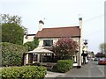
6
The 'Gothic Cottage', Church Walk, Tettenhall
A locally listed building next to the churchyard built around 1840 in the Tudor Revival Style. Originally pale yellow brick the painted exterior is a mid 20th century addition.
Image: © John M
Taken: 21 Apr 2007
0.06 miles
7
Lower Street View
The view near Lower Green Tettenhall, Wolverhampton.
Image: © Gordon Griffiths
Taken: 20 Jan 2022
0.07 miles
8
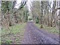
Mile Post View
The view along the railway path in Claregate, Wolverhampton.
Image: © Gordon Griffiths
Taken: 21 Feb 2018
0.07 miles
9
Tettenhall, health centre
Lower Green Health Centre, on Aldersley Road: http://www.tettenhallmedicalpractice.nhs.uk/contact-us-3/
Image: © Mike Faherty
Taken: 30 Jun 2013
0.07 miles
10

Tettenhall, primary school
St Michael's C.E.(A) Primary School, on Lower Street. There is a stone plaque beneath the gable, with "National School"; modern buildings are behind, out of sight. http://www.stmichaelsce.org.uk/about.html
Image: © Mike Faherty
Taken: 30 Jun 2013
0.08 miles