IMAGES TAKEN NEAR TO
Popes Lane, WOLVERHAMPTON, WV6 8TX
Introduction
This page details the photographs taken nearby to Popes Lane, WV6 8TX by members of the Geograph project.
The Geograph project started in 2005 with the aim of publishing, organising and preserving representative images for every square kilometre of Great Britain, Ireland and the Isle of Man.

There are currently over 7.5m images from over14,400 individuals and you can help contribute to the project by visiting https://www.geograph.org.uk
Image Map
Images are licensed for reuse under creativecommons.org/licenses/by-sa/2.0
Notes
- Clicking on the map will re-center to the selected point.
- The higher the marker number, the further away the image location is from the centre of the postcode.
Image Listing (37 Images Found)
Images are licensed for reuse under creativecommons.org/licenses/by-sa/2.0
Image
Details
Distance
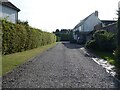
1
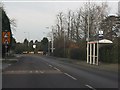
Wrottesley Park Nursing Home
The nursing home has a long frontage on the Wergs Road. A new development adjacent will offer housing for senior citizens.
Image: © John M
Taken: 30 Dec 2006
0.07 miles
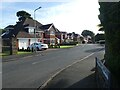
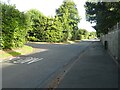
5
Junction of Woodthorne Road, Keepers Lane, and the A41 Wergs Road
Image: © ElfExplorer
Taken: 21 Aug 2024
0.12 miles
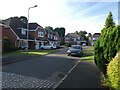
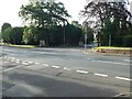
7
Junction of Chatsworth Gardens and Keepers Lane
Image: © ElfExplorer
Taken: 21 Aug 2024
0.13 miles
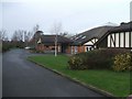
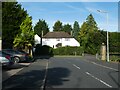
8
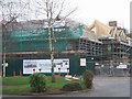
New Care Home on the Wergs Road
A major new residential and care home for Sunrise Senior Living is taking shape, adjacent to the Wrottesley Park Nursing Home.
Image: © John M
Taken: 30 Dec 2006
0.13 miles