IMAGES TAKEN NEAR TO
Kirton Grove, WOLVERHAMPTON, WV6 8RX
Introduction
This page details the photographs taken nearby to Kirton Grove, WV6 8RX by members of the Geograph project.
The Geograph project started in 2005 with the aim of publishing, organising and preserving representative images for every square kilometre of Great Britain, Ireland and the Isle of Man.

There are currently over 7.5m images from over14,400 individuals and you can help contribute to the project by visiting https://www.geograph.org.uk
Image Map (Loading...)


Getting Data...Please wait
Leaflet Map data © OpenStreetMap
Images are licensed for reuse under creativecommons.org/licenses/by-sa/2.0
Notes
- Clicking on the map will re-center to the selected point.
- The higher the marker number, the further away the image location is from the centre of the postcode.
Image Listing (89 Images Found)
Images are licensed for reuse under creativecommons.org/licenses/by-sa/2.0
Image
Details
Distance
2

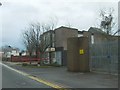
Tettenhall Pumping Station
A mid 19th century water pumping station, now in the care of Severn Trent Water whose compound it sits in. It was designed by Henry Marlen, and built in 1845, at a time when there were several reservoirs and settling pools close by, presumably to supply a clean water into the growing town of Wolverhampton. A Grade II listing https://britishlistedbuildings.co.uk/101207848-tettenhall-pumping-station-tettenhall-wightwick-ward#.YecZU_7P3IU & https://historicengland.org.uk/listing/the-list/list-entry/1207848 was granted in 1991. The Image lies just offshot to the right of this photo.
Image: © Richard Law
Taken: 18 Jan 2022
0.05 miles
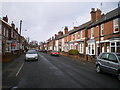
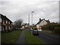
4
Regis Road
The view in Tettenhall, Wolverhampton.
Image: © Gordon Griffiths
Taken: 23 Nov 2020
0.06 miles
6

House of the Waterworks Manager - Tettenhall pumping station
Located within the same Severn Trent compound as Image, and of a similar mid 19th century date as that industrial building, this house for the works manager was Grade II listed https://britishlistedbuildings.co.uk/101282446-former-managers-house-to-north-of-former-pump-house-tettenhall-wightwick-ward#.YecbVP7P3IU & https://historicengland.org.uk/listing/the-list/list-entry/1282446 in 1991. Until fairly recently it was in use as Severn Trent offices.
Image: © Richard Law
Taken: 18 Jan 2022
0.06 miles
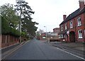
8
Grange Road, Tettenhall
Looking north from opposite the end of Limes Road.
Image: © Richard Vince
Taken: 10 Jan 2014
0.07 miles
9
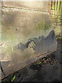
OS benchmark - Tettenhall, pillar on N side of Regis Road
An OS cutmark on a former gatepillar; last levelled in 1957 at 139.705m above Ordnance Datum Newlyn.
Image: © Richard Law
Taken: 18 Jan 2022
0.09 miles
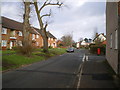
10
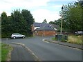
Junction of Cornwall Road and Grange Road
Image: © ElfExplorer
Taken: 3 Aug 2024
0.10 miles