IMAGES TAKEN NEAR TO
Mount Road, WOLVERHAMPTON, WV6 8HP
Introduction
This page details the photographs taken nearby to Mount Road, WV6 8HP by members of the Geograph project.
The Geograph project started in 2005 with the aim of publishing, organising and preserving representative images for every square kilometre of Great Britain, Ireland and the Isle of Man.

There are currently over 7.5m images from over14,400 individuals and you can help contribute to the project by visiting https://www.geograph.org.uk
Image Map
Images are licensed for reuse under creativecommons.org/licenses/by-sa/2.0
Notes
- Clicking on the map will re-center to the selected point.
- The higher the marker number, the further away the image location is from the centre of the postcode.
Image Listing (100 Images Found)
Images are licensed for reuse under creativecommons.org/licenses/by-sa/2.0
Image
Details
Distance
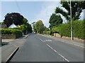

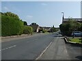
3
Junction of Fairoak Drive and Mount Road
Image: © ElfExplorer
Taken: 1 Aug 2024
0.04 miles
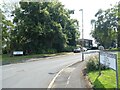
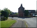
9
Junction of Mount Road and Dippons Drive
Image: © ElfExplorer
Taken: 1 Aug 2024
0.08 miles
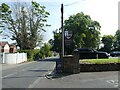
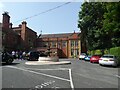
10
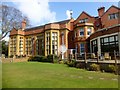
Tettenhall Wood
Parked in the large Mount Hotel car park and then had a good walk around. The Mount Hotel is the former home of Charles Benjamin Mander, a paint and varnish manufacturer. The house was built in 1865, extended in 1891, ballroom built in 1908 and the house was sold in 1952.
Name: Tettenhall Wood
Hill number: 17199
Height: 156m / 512ft
Parent (Ma/M): 2843 The Wrekin
Section: 39: Central and Eastern England
County/UA: Wolverhampton (UA)
Class: Tump (100-199m)
Grid ref: SO875988 (est)
Drop: 31m
Col: 125m SO864991
Image: © Rude Health
Taken: 25 Mar 2015
0.09 miles