IMAGES TAKEN NEAR TO
Cheswell Close, WOLVERHAMPTON, WV6 8AS
Introduction
This page details the photographs taken nearby to Cheswell Close, WV6 8AS by members of the Geograph project.
The Geograph project started in 2005 with the aim of publishing, organising and preserving representative images for every square kilometre of Great Britain, Ireland and the Isle of Man.

There are currently over 7.5m images from over14,400 individuals and you can help contribute to the project by visiting https://www.geograph.org.uk
Image Map
Images are licensed for reuse under creativecommons.org/licenses/by-sa/2.0
Notes
- Clicking on the map will re-center to the selected point.
- The higher the marker number, the further away the image location is from the centre of the postcode.
Image Listing (123 Images Found)
Images are licensed for reuse under creativecommons.org/licenses/by-sa/2.0
Image
Details
Distance
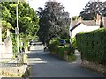
1
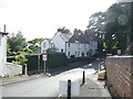
Junction of Ormes Lane, Church Road, and The Holloway
Image: © ElfExplorer
Taken: 3 Aug 2024
0.02 miles
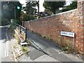
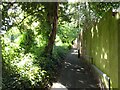
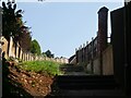
3
Public footpath between Forton Close and Cheswell Close
Image: © ElfExplorer
Taken: 29 Aug 2024
0.04 miles
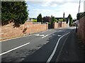
4
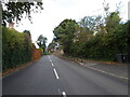
The Holloway
The Holloway leads up towards Tettenhall Wood from the Bridgnorth Road in Compton, Wolverhampton.
Image: © Gordon Griffiths
Taken: 15 Oct 2020
0.04 miles
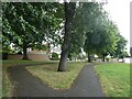
9
Public footpath between Church Road and Broxwood Park
Image: © ElfExplorer
Taken: 2 Aug 2024
0.06 miles
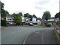
10
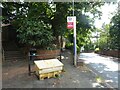
Bus stop and two footpaths off Church Road
Image: © ElfExplorer
Taken: 2 Aug 2024
0.06 miles