IMAGES TAKEN NEAR TO
Badger Lane, WOLVERHAMPTON, WV6 7JR
Introduction
This page details the photographs taken nearby to Badger Lane, WV6 7JR by members of the Geograph project.
The Geograph project started in 2005 with the aim of publishing, organising and preserving representative images for every square kilometre of Great Britain, Ireland and the Isle of Man.

There are currently over 7.5m images from over14,400 individuals and you can help contribute to the project by visiting https://www.geograph.org.uk
Image Map (Loading...)


Getting Data...Please wait
Leaflet Map data © OpenStreetMap
Images are licensed for reuse under creativecommons.org/licenses/by-sa/2.0
Notes
- Clicking on the map will re-center to the selected point.
- The higher the marker number, the further away the image location is from the centre of the postcode.
Image Listing (75 Images Found)
Images are licensed for reuse under creativecommons.org/licenses/by-sa/2.0
Image
Details
Distance
1
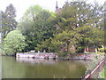
Duck Pond, Badger
This pond lies in front of St Giles Church, Badger. The church was built in 1834.
Image: © A Holmes
Taken: 21 Apr 2007
0.00 miles
2
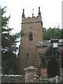
The clock tower of St Giles Parish Church
Image: © Richard Law
Taken: 17 Aug 2008
0.01 miles
3
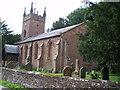
The Parish Church of St Giles, Badger
As with many of the large buildings in the area, this small church is built of the local sandstone.
Image: © Richard Law
Taken: 17 Aug 2008
0.02 miles
4
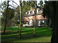
Badger Old Hall
Thought to date from around 1700, what stands here now is not actually the Old Hall (which is long gone) - it is the former service wing to the hall. It was Grade II listed https://britishlistedbuildings.co.uk/101367637-the-old-hall-badger#.YHvqjehKjIU & https://historicengland.org.uk/listing/the-list/list-entry/1367637 in 1984.
Image: © Richard Law
Taken: 23 Feb 2020
0.02 miles
5
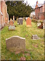
Here Lieth the Body
The Tombstone of Mary Tedstill in St Giles Churchyard Badger.
Image: © Gordon Griffiths
Taken: 12 Mar 2010
0.02 miles
6
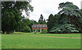
Badger Hall near Ackleton
The current hall is an old service wing of the original house which was pulled down in 1952. It was built c1700, although it has been altered since. Grade II listed.
On the right is a beautiful cedar tree, its blue-green colouring suggesting it may be the glaucous form of the Atlantic or Atlas cedar.
Image: © Stephen Richards
Taken: Unknown
0.02 miles
7
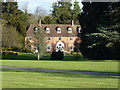
Badger Old Hall
The current house is in reality the former service wing to the original Hall, which was demolished in the early 1950s. This remaining building is believed to be early 18th century and is certainly a pretty impressive place in itself. Grade II listed https://britishlistedbuildings.co.uk/101367637-the-old-hall-badger#.XmAzJ6j7TIU & https://historicengland.org.uk/listing/the-list/list-entry/1367637 in 1984.
Image: © Richard Law
Taken: 1 Mar 2020
0.02 miles
8
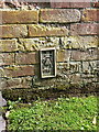
OS flush bracket 10560
OS Flush Bracket 10560 on the wall at the entrance to the hall beyond the church; originally levelled in 1959 at 73.988m above Ordnance Datum Newlyn.
Image: © Richard Law
Taken: 20 Jul 2014
0.02 miles
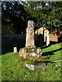
9
Medieval Cross, St Giles Church, Badger
The Grade-II* Listed medieval cross within the grounds of St, Giles Church, Badger. The cross dates from the 14th or 15th Century and may have been originally been sited elsewhere in the village.
Image: © Anthony Rowley
Taken: 22 Jun 2022
0.02 miles
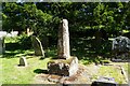
10
Stump of churchyard cross, St Giles' church
Thought to be 14th or 15th century, but obviously now missing its head which was removed in the 19th century and subsequently lost; the cross-shaft is split, which may have been the reason the head was taken off. The remains as seen now were Grade II* listed https://britishlistedbuildings.co.uk/101221769-churchyard-cross-about-5-metres-south-east-of-the-chancel-of-the-church-of-st-giles-badger#.YHvpBuhKjIU & https://historicengland.org.uk/listing/the-list/list-entry/1221769 in 1984.
Image: © Richard Law
Taken: 23 Feb 2020
0.03 miles