IMAGES TAKEN NEAR TO
WOLVERHAMPTON, WV6 6GW
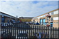
Introduction
This page details the photographs taken nearby to WV6 6GW by members of the Geograph project.
The Geograph project started in 2005 with the aim of publishing, organising and preserving representative images for every square kilometre of Great Britain, Ireland and the Isle of Man.

There are currently over 7.5m images from over14,400 individuals and you can help contribute to the project by visiting https://www.geograph.org.uk
Image Map
Images are licensed for reuse under creativecommons.org/licenses/by-sa/2.0
Notes
- Clicking on the map will re-center to the selected point.
- The higher the marker number, the further away the image location is from the centre of the postcode.
Image Listing (174 Images Found)
Images are licensed for reuse under creativecommons.org/licenses/by-sa/2.0
Image
Details
Distance
1
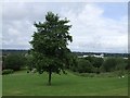
Lone Tree on Dunstall Hill
Looking down the slope of the hill towards the racecourse and the sandstone ridge at Tettenhall. In past years the feature on the landscape would have been the three chimney stacks at Courtaulds.
Image: © John M
Taken: 16 Jun 2007
0.03 miles
2
Ex GWR workshop site
Dunstall Hill Industrial Estate occupies the site of the former GWR Stafford Road Works. The works originally built locomotives until production was transferred to Swindon in 1908 but it remained an important railway workshop for heavy repairs and maintenance. The works eventually closed in the Beeching era.
Image: © John M
Taken: 21 Apr 2007
0.05 miles
3
Chord from WCML joining Shrewsbury Line
The electrified section of line continues over the Dunstall Viaduct to the West Coast Traincare Depot at Oxley Sidings. The land on the right was formerly the GWR's Stafford Road Works.
Image: © John M
Taken: 21 Apr 2007
0.07 miles
4
Dunstall Hill Junction
The view of the junction with Dunstall Avenue in Wolverhampton.
Image: © Gordon Griffiths
Taken: 4 Mar 2015
0.08 miles
5
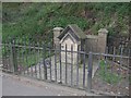
Lady Wulfruna's Well
This memorial dated 1901 marks the site of Lady Wulfruna's well. The Lady Wulfruna endowed the Collegiate church of Wolverhampton with a Dean and Prebendaries in AD994, giving her name to the town: Wulfrun's Heanton (High Town).
The tap and drinking cup that once graced the well are a distant memory to only the oldest residents of the borough.
A statue to the Lady Wulfrun can be found near St Peter's Church.
Image: © John M
Taken: 21 Apr 2007
0.09 miles
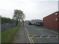
6
Gorsebrook Road, Oxley
From the railway bridge.
Image: © Andrew Abbott
Taken: 25 May 2019
0.10 miles
8
Dunstall View
The view from Gorsebrook Road to the viaduct of the Wolverhampton to Shrewsbury Railway line.
Image: © Gordon Griffiths
Taken: 17 Oct 2010
0.11 miles
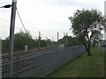
10
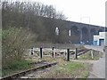
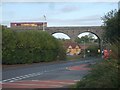
Dunstall Viaduct from Gorsebrook Road
The blue brick viaduct carries the main line north from Wolverhampton towards Crewe. The area south of Gorsebrook Road was the Stafford Road Works of the GWR from 1849. Between 1859 and 1908 over 800 locomotives were built on this site. The workshops finally closed in 1964. The rail track here was put in at great expense to remember this trade.
I am told that when the circus came to town in the 1950s that the elephants were housed in the grey building. They were walked here from the nearby railway halt.
Image: © John M
Taken: 25 Mar 2007
0.12 miles