IMAGES TAKEN NEAR TO
Whernside Drive, WOLVERHAMPTON, WV6 0TJ
Introduction
This page details the photographs taken nearby to Whernside Drive, WV6 0TJ by members of the Geograph project.
The Geograph project started in 2005 with the aim of publishing, organising and preserving representative images for every square kilometre of Great Britain, Ireland and the Isle of Man.

There are currently over 7.5m images from over14,400 individuals and you can help contribute to the project by visiting https://www.geograph.org.uk
Image Map
Images are licensed for reuse under creativecommons.org/licenses/by-sa/2.0
Notes
- Clicking on the map will re-center to the selected point.
- The higher the marker number, the further away the image location is from the centre of the postcode.
Image Listing (29 Images Found)
Images are licensed for reuse under creativecommons.org/licenses/by-sa/2.0
Image
Details
Distance
1
The Golden Eagle
A pub on the corner of Court Road and Hordern Road.
Image: © Bill Boaden
Taken: 22 May 2011
0.22 miles
2
Ferndale Avenue
The view in Wolverhampton on a rainy day.
Image: © Gordon Griffiths
Taken: 25 Oct 2019
0.22 miles
3
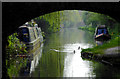
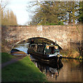
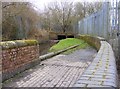
Canal near Wolverhampton Racecourse
Looking south-west through the arch of Bridge No 62, Dunstall Water Bridge.
Image: © Roger D Kidd
Taken: 7 May 2016
0.22 miles
4
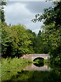
Canal near Wolverhampton Racecourse
Ahead is Dunstall Water Bridge, No 63.
The original name of the Tunstall neighbourhood was already considered out of date by late Victorian times, but this bridge was built in the late eighteenth century, and is still plated with the original spelling. http://www.blackcountrybugle.co.uk/Wolverhamptons-lost-village-Woundon/story-20148821-detail/story.html
Image: © Roger D Kidd
Taken: 30 Aug 2010
0.23 miles
5
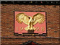
Detail on The Golden Eagle
Detail of the pub sign on the Golden Eagle. Clearly it was built in the mid 1920s, and was apparently contemporaneous with the Courtaulds factory on the opposite side of Hordern Road, which opened in the same year.
Image: © Richard Law
Taken: 13 May 2009
0.23 miles
6
February Cruising, Staffordshire and Worcestershire Canal
Well wrapped up, the lower ranked (!) crew of the narrowboat "Joker" enjoy the late afternoon sun as they negotiate Dunstall Water Bridge.
The original name of the Tunstall neighbourhood was already considered out of date by late Victorian times, but this bridge was built in the late eighteenth century, and is still plated with the original spelling. http://www.blackcountrybugle.co.uk/Wolverhamptons-lost-village-Woundon/story-20148821-detail/story.htm
Image]
Image: © Roger D Kidd
Taken: 8 Feb 2008
0.23 miles
7
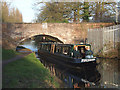
Staffordshire and Worcestershire Canal near Wolverhampton
Narrowboat "Joker" is seen in front of Dunstall Water Bridge. The picture of the top of this unusual bridge shows its purpose perfectly. Image]
The original name of the Tunstall neighbourhood was already considered out of date by late Victorian times, but this bridge was built in the late eighteenth century, and is still plated with the original spelling. http://www.blackcountrybugle.co.uk/Wolverhamptons-lost-village-Woundon/story-20148821-detail/story.htm
Image: © Roger D Kidd
Taken: 8 Feb 2008
0.23 miles
8
![Tunstall [or Dunstall] Water Bridge, No 63](https://s2.geograph.org.uk/geophotos/05/79/40/5794090_39e1a210_120x120.jpg)
Tunstall [or Dunstall] Water Bridge, No 63
An aqueduct carrying Smestow Brook over the Staff & Worcs canal.
Image: © Christine Johnstone
Taken: 7 May 2018
0.23 miles
9
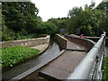
Aqueduct Scene
The view of the Dunstall Water Bridge where the Smestow Brook passes over the Staffordshire and Worcestershire Canal near Wolverhampton.
Image: © Gordon Griffiths
Taken: 28 Sep 2020
0.23 miles
10
Dunstall Water Bridge
The view of Smestow Brook passing over the Staffordshire and Worcestershire Canal near Wolverhampton.
Image: © Gordon Griffiths
Taken: 21 Feb 2018
0.23 miles