IMAGES TAKEN NEAR TO
Craddock Street, WOLVERHAMPTON, WV6 0QJ
Introduction
This page details the photographs taken nearby to Craddock Street, WV6 0QJ by members of the Geograph project.
The Geograph project started in 2005 with the aim of publishing, organising and preserving representative images for every square kilometre of Great Britain, Ireland and the Isle of Man.

There are currently over 7.5m images from over14,400 individuals and you can help contribute to the project by visiting https://www.geograph.org.uk
Image Map
Images are licensed for reuse under creativecommons.org/licenses/by-sa/2.0
Notes
- Clicking on the map will re-center to the selected point.
- The higher the marker number, the further away the image location is from the centre of the postcode.
Image Listing (8 Images Found)
Images are licensed for reuse under creativecommons.org/licenses/by-sa/2.0
Image
Details
Distance
1
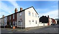
Jackson Street
The view near Whitmore Reans, Wolverhampton
Image: © Gordon Griffiths
Taken: 28 Oct 2022
0.07 miles
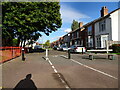
2
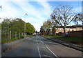
Craddock Street
The view near Whitmore Reans, Wolverhampton.
Image: © Gordon Griffiths
Taken: 28 Oct 2022
0.13 miles
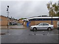
3
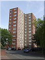
Council Housing - Lowe Street
The rear view of the Whitmore Reans tower blocks.
Image: © John M
Taken: 21 May 2011
0.20 miles
4
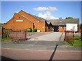
The Church of God of Prophecy, Whitmore Reans
An unusual name for a church - not one that I've come across before, at any rate.
Image: © Richard Law
Taken: 27 Jul 2009
0.22 miles
5
Chester Street
The view from by New Hampton Road West in Wolverhampton.
Image: © Gordon Griffiths
Taken: 28 Sep 2022
0.24 miles
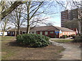
7
Whitmore Reans Library
Next to the Avion Shopping Centre.
Image: © John M
Taken: 9 Feb 2008
0.25 miles
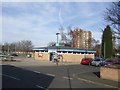
8
Whitmore Reans Library
The view in Wolverhampton on a rainy day.
Image: © Gordon Griffiths
Taken: 25 Oct 2019
0.25 miles