IMAGES TAKEN NEAR TO
Gorsebrook Road, WOLVERHAMPTON, WV6 0PE
Introduction
This page details the photographs taken nearby to Gorsebrook Road, WV6 0PE by members of the Geograph project.
The Geograph project started in 2005 with the aim of publishing, organising and preserving representative images for every square kilometre of Great Britain, Ireland and the Isle of Man.

There are currently over 7.5m images from over14,400 individuals and you can help contribute to the project by visiting https://www.geograph.org.uk
Image Map
Images are licensed for reuse under creativecommons.org/licenses/by-sa/2.0
Notes
- Clicking on the map will re-center to the selected point.
- The higher the marker number, the further away the image location is from the centre of the postcode.
Image Listing (147 Images Found)
Images are licensed for reuse under creativecommons.org/licenses/by-sa/2.0
Image
Details
Distance
1
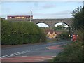
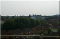
Dunstall View
The view from Gorsebrook Road to the viaduct of the Wolverhampton to Shrewsbury Railway line.
Image: © Gordon Griffiths
Taken: 17 Oct 2010
0.03 miles
3
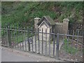
Lady Wulfruna's Well
This memorial dated 1901 marks the site of Lady Wulfruna's well. The Lady Wulfruna endowed the Collegiate church of Wolverhampton with a Dean and Prebendaries in AD994, giving her name to the town: Wulfrun's Heanton (High Town).
The tap and drinking cup that once graced the well are a distant memory to only the oldest residents of the borough.
A statue to the Lady Wulfrun can be found near St Peter's Church.
Image: © John M
Taken: 21 Apr 2007
0.06 miles
4
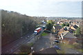
Gorsebrook Road, Oxley
From the railway bridge.
Image: © Andrew Abbott
Taken: 25 May 2019
0.06 miles
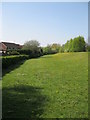
5
Houses on Viaduct Drive, from the railway
Image: © Christopher Hilton
Taken: 9 Jun 2016
0.07 miles
6
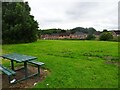
Recreation area between canal and Viaduct housing estate
Image: © Terry Cooper
Taken: 19 Apr 2019
0.08 miles
7
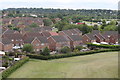
Houses on Viaduct Drive
From the railway
Image: © Andrew Abbott
Taken: 25 May 2019
0.09 miles
8
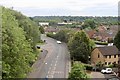
Bench View
The view from near the Bridge at Lock 17 on the Birmingham Canal, towards The Chase houses in Dunstall, Wolverhampton.
Image: © Gordon Griffiths
Taken: 3 Jun 2024
0.09 miles
9
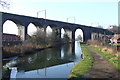
Viaduct across Canal, Wolverhampton
The Birmingham Canal Navigation cut,(opened 1772), linked Birmingham with the Staffordshire and Worcestershire Canal at Aldersley, about one kilometre beyond the viaduct, which carries the main line to Telford and Shrewsbury.
Image: © Roger D Kidd
Taken: 17 Feb 2008
0.11 miles
10
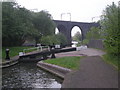
Lock No 16 & Dunstall Viaduct
The canal is the extension to the Birmingham to Wolverhampton network. From here it continues a little way until the junction with the Staffordshire & Worcester Canal at Aldersley. The viaduct carries the ex-GWR line to Shrewsbury, then on to central Wales and Chester. This section is the only electrified part of this route as it provides power to the trains at Oxley depot.
Image: © Row17
Taken: 7 May 2008
0.11 miles