IMAGES TAKEN NEAR TO
Marlborough Gardens, WOLVERHAMPTON, WV6 0LU
Introduction
This page details the photographs taken nearby to Marlborough Gardens, WV6 0LU by members of the Geograph project.
The Geograph project started in 2005 with the aim of publishing, organising and preserving representative images for every square kilometre of Great Britain, Ireland and the Isle of Man.

There are currently over 7.5m images from over14,400 individuals and you can help contribute to the project by visiting https://www.geograph.org.uk
Image Map
Images are licensed for reuse under creativecommons.org/licenses/by-sa/2.0
Notes
- Clicking on the map will re-center to the selected point.
- The higher the marker number, the further away the image location is from the centre of the postcode.
Image Listing (108 Images Found)
Images are licensed for reuse under creativecommons.org/licenses/by-sa/2.0
Image
Details
Distance
2
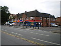
Parade of shops at Newbridge
These lie directly opposite the Newbridge pub Image
Image: © Richard Law
Taken: 24 Jul 2009
0.07 miles
3
Tettenhall Road Junction
The view from New Hampton Road West in Wolverhampton.
Image: © Gordon Griffiths
Taken: 6 Nov 2016
0.08 miles
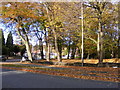
5
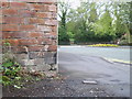
Benchmark - Newhampton Road
Benchmark cut into the brickwork of a wall at the western end of the Newhampton Road
Image: © Richard Law
Taken: 30 Apr 2010
0.09 miles
6
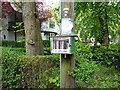
The Newbridge Mini Library
This box holds a rare selection of (roughly) a dozen books for free loan, including a guide to Buddhist Christianity and something a little racier from Joan Collins. All rather eclectic.
Image: © Richard Law
Taken: 26 May 2016
0.10 miles
7
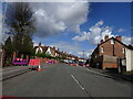
Newhampton Road West Lights
The view of the roadworks in Tettenhall, Wolverhampton.
Image: © Gordon Griffiths
Taken: 6 May 2021
0.11 miles
8
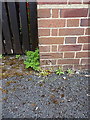
OS benchmark - Newbridge, Telephone Exchange building
OS cutmark located on the front of the BT building (which is still the local telephone exchange for the Tettenhall area) on Crowther Road; originally levelled at 111.825m above Ordnance Datum Newlyn.
Image: © Richard Law
Taken: 26 May 2016
0.13 miles
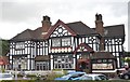
9
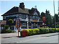
The Newbridge
A pub on the Tettenhall Road.
Image: © Gordon Griffiths
Taken: 30 Apr 2007
0.13 miles
10
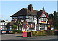
The Newbridge, Tettenhall Road, Wolverhampton
A popular main road pub concentrating on serving meals.
Image: © Roger D Kidd
Taken: 8 Feb 2008
0.14 miles