IMAGES TAKEN NEAR TO
Stokes Gardens, WOLVERHAMPTON, WV6 0EL
Introduction
This page details the photographs taken nearby to Stokes Gardens, WV6 0EL by members of the Geograph project.
The Geograph project started in 2005 with the aim of publishing, organising and preserving representative images for every square kilometre of Great Britain, Ireland and the Isle of Man.

There are currently over 7.5m images from over14,400 individuals and you can help contribute to the project by visiting https://www.geograph.org.uk
Image Map
Images are licensed for reuse under creativecommons.org/licenses/by-sa/2.0
Notes
- Clicking on the map will re-center to the selected point.
- The higher the marker number, the further away the image location is from the centre of the postcode.
Image Listing (61 Images Found)
Images are licensed for reuse under creativecommons.org/licenses/by-sa/2.0
Image
Details
Distance
1
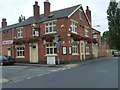
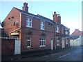
The Newhampton
A Pub on the corner of Sweetman Street.
Image: © Gordon Griffiths
Taken: 14 Jul 2008
0.04 miles
2
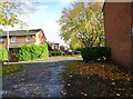
Riches Road Junction
The view of the junction with Allen Road in the Newbridge area of Wolverhampton.
Image: © Gordon Griffiths
Taken: 28 Oct 2022
0.04 miles
3
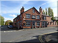
The Newhampton Pub
A Pub on the corner of Sweetman Street and Riches Road in Wolverhampton.
Image: © Gordon Griffiths
Taken: 28 Oct 2022
0.05 miles
4
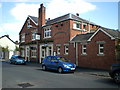
The Newhampton inn
On the corner of Riches Street and Sweetman Street.
Image: © Richard Law
Taken: 7 Sep 2014
0.05 miles
5
The Newhampton
Victorian PH on Riches Street.
Image: © John M
Taken: 13 Feb 2014
0.06 miles
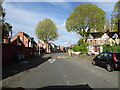
6
Sweetman Street
The view in the Newbridge area of Wolverhampton.
Image: © Gordon Griffiths
Taken: 28 Oct 2022
0.07 miles
7
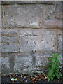
OS benchmark - Park Dale, St Jude's Rd
An OS cutmark in the wall bounding the church land facing onto St Jude's Road; originally levelled at 121.896m above Ordnance Datum Newlyn.
Image: © Richard Law
Taken: 7 Sep 2014
0.07 miles
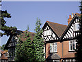
8
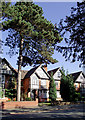
Housing in Tettenhall Road, Wolverhampton
Late Victorian substantial housing near Newbridge. One of the eaves bears the date 1892.
Tettenhall Road is the A41 road to Newport, Whitchurch and Chester. As Wolverhampton spread along this road in the late 19th and early 20th centuries, most of the dwellings were built for the more affluent members of society.
Image: © Roger D Kidd
Taken: 13 Oct 2010
0.10 miles
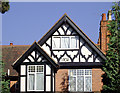
9
Housing (detail) in Tettenhall Road, Wolverhampton
This late Victorian substantial housing is near Newbridge. The decoration on the eaves varies from house to house. http://www.geograph.org.uk/photo/2123245
Tettenhall Road is the A41 road to Newport, Whitchurch and Chester. As Wolverhampton spread along this road in the late 19th and early 20th centuries, most of the dwellings were built for the more affluent members of society.
Image: © Roger D Kidd
Taken: 13 Oct 2010
0.10 miles
10
Housing (detail) in Tettenhall Road, Wolverhampton
Late Victorian substantial housing near Newbridge. The decoration on the eaves varies from house to house. Image
Tettenhall Road is the A41 road to Newport, Whitchurch and Chester. As Wolverhampton spread along this road in the late 19th and early 20th centuries, most of the dwellings were built for the more affluent members of society.
Image: © Roger D Kidd
Taken: 13 Oct 2010
0.10 miles