IMAGES TAKEN NEAR TO
Riches Street, WOLVERHAMPTON, WV6 0DR
Introduction
This page details the photographs taken nearby to Riches Street, WV6 0DR by members of the Geograph project.
The Geograph project started in 2005 with the aim of publishing, organising and preserving representative images for every square kilometre of Great Britain, Ireland and the Isle of Man.

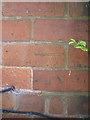
There are currently over 7.5m images from over14,400 individuals and you can help contribute to the project by visiting https://www.geograph.org.uk
Image Map
Images are licensed for reuse under creativecommons.org/licenses/by-sa/2.0
Notes
- Clicking on the map will re-center to the selected point.
- The higher the marker number, the further away the image location is from the centre of the postcode.
Image Listing (71 Images Found)
Images are licensed for reuse under creativecommons.org/licenses/by-sa/2.0
Image
Details
Distance
1
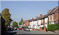
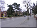
Riches Street near Newbridge, Wolverhampton
Looking north from near the junction with Albert Road and Tettenhall Road.
Image: © Roger D Kidd
Taken: 13 Oct 2010
0.01 miles
2
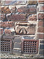
OS benchmark - Park Dale, Riches Street
An OS cutmark on the roadside wall in Riches Street; originally levelled at 124.508m above Ordnance Datum Newlyn.
Image: © Richard Law
Taken: 7 Sep 2014
0.01 miles
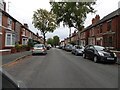
4
Riches Road
The view along the road in the Newbridge area of Wolverhampton.
Image: © Gordon Griffiths
Taken: 28 Oct 2022
0.03 miles
5
OS benchmark - Park Dale, no 4 Avondale Rd
An OS cutmark in the brickwork at the side of no 4 Avondale Rd; originally levelled at 124.572m above Ordnance Datum Newlyn.
Image: © Richard Law
Taken: 7 Sep 2014
0.04 miles
6
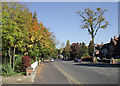
Albert Road, Wolverhampton
This is Albert Road looking towards West Park from the junction with Tettenhall Road.
Image: © Roger D Kidd
Taken: 13 Oct 2010
0.06 miles
7
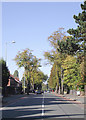
Tettenhall Road, Wolverhampton
Looking towards Newbridge along the A41, which leads to Newport, Whitchurch and Chester. Historically Tettenhall and this road have been home to the better off, and there are very many grand properties, dating from the early part of the twentieth century, as well as some more modest terraced dwellings. Many businesses and professional practices are now located in the larger premises.
Image: © Roger D Kidd
Taken: 13 Oct 2010
0.07 miles
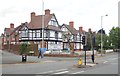
8
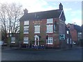
Halfway House
Undergoing conversion to a doctor's surgery and medical centre. Image
Image: © John M
Taken: 13 Feb 2014
0.08 miles
9
Albert Road
The view near the Tettenhall Road in Wolverhampton.
Image: © Gordon Griffiths
Taken: 20 Mar 2016
0.09 miles
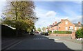
10
Avondale Road
The view along the road towards Allen Road in Wolverhampton.
Image: © Gordon Griffiths
Taken: 28 Sep 2020
0.09 miles