IMAGES TAKEN NEAR TO
Tettenhall Road, WOLVERHAMPTON, WV6 0BP
Introduction
This page details the photographs taken nearby to Tettenhall Road, WV6 0BP by members of the Geograph project.
The Geograph project started in 2005 with the aim of publishing, organising and preserving representative images for every square kilometre of Great Britain, Ireland and the Isle of Man.

There are currently over 7.5m images from over14,400 individuals and you can help contribute to the project by visiting https://www.geograph.org.uk
Image Map (Loading...)


Getting Data...Please wait
Leaflet Map data © OpenStreetMap
Images are licensed for reuse under creativecommons.org/licenses/by-sa/2.0
Notes
- Clicking on the map will re-center to the selected point.
- The higher the marker number, the further away the image location is from the centre of the postcode.
Image Listing (61 Images Found)
Images are licensed for reuse under creativecommons.org/licenses/by-sa/2.0
Image
Details
Distance
1
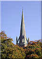
The spire of St Jude's Church, Wolverhampton
The church is on the A41 Tettenhall Road near Newbridge.
Being enclosed by buildings or very mature trees, St Jude's Church is quite elusive to photograph well, so I have made do with showing off this lovely spire today. Winter is the time to come back again. The church was built during 1867-1869, the spire being added later.
The church website has nothing to say about its history, but this one does a good job: http://www.localhistory.scit.wlv.ac.uk/listed/stjudes.htm .
Image: © Roger D Kidd
Taken: 13 Oct 2010
0.01 miles
2
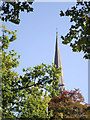
Autumn leaves and church spire near Newbridge, Wolverhampton
The church is on the Tettenhall Road, A41.
Being enclosed by buildings or very mature trees, St Jude's Church is quite elusive to photograph well, so I have made do with showing off this lovely spire today. Winter is the time to come back again. The church was built during 1867-1869, the spire being added later.
The church website has nothing to say about its history, but this one does a good job: http://www.localhistory.scit.wlv.ac.uk/listed/stjudes.htm .
Image: © Roger D Kidd
Taken: 13 Oct 2010
0.01 miles
3
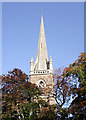
The spire of St Jude's Church, Wolverhampton
The church is on Tettenhall Road near Newbridge.
Being enclosed by buildings or very mature trees, St Jude's Church is quite elusive to photograph well, so I have made do with showing off this lovely spire today. Winter is the time to come back again. The church was built during 1867-1869, the spire being added later.
The church website has nothing to say about its history, but this one does a good job: http://www.localhistory.scit.wlv.ac.uk/listed/stjudes.htm .
Image: © Roger D Kidd
Taken: 13 Oct 2010
0.01 miles
4
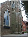
Saint Jude's
A C of E Church on the Tettenhall Road.
Image: © Gordon Griffiths
Taken: 14 Jul 2008
0.03 miles
5
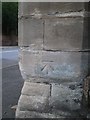
OS benchmark - St Jude's church, Tettenhall Road
An OS cutmark in a stone pillar at the front corner of the garden of St Jude's church. This was originally levelled at 121.534m above Ordnance Datum Newlyn.
Image: © Richard Law
Taken: 22 Aug 2013
0.03 miles
6
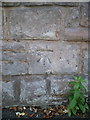
OS benchmark - Park Dale, St Jude's Rd
An OS cutmark in the wall bounding the church land facing onto St Jude's Road; originally levelled at 121.896m above Ordnance Datum Newlyn.
Image: © Richard Law
Taken: 7 Sep 2014
0.05 miles
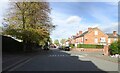
7
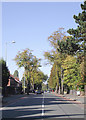
Tettenhall Road, Wolverhampton
Looking towards Newbridge along the A41, which leads to Newport, Whitchurch and Chester. Historically Tettenhall and this road have been home to the better off, and there are very many grand properties, dating from the early part of the twentieth century, as well as some more modest terraced dwellings. Many businesses and professional practices are now located in the larger premises.
Image: © Roger D Kidd
Taken: 13 Oct 2010
0.06 miles
8
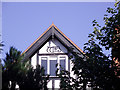
Housing (detail) in Tettenhall Road, Wolverhampton
Late Victorian substantial housing near Newbridge. The decoration on the eaves varies from house to house. One bears the date 1892. Image
Tettenhall Road is the A41 road to Newport, Whitchurch and Chester. As Wolverhampton spread along this road in the late 19th and early 20th centuries, most of the dwellings were built for the more affluent members of society.
Image: © Roger D Kidd
Taken: 13 Oct 2010
0.06 miles
9
Riches Road
The view along the road in the Newbridge area of Wolverhampton.
Image: © Gordon Griffiths
Taken: 28 Oct 2022
0.07 miles
10
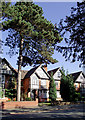
Housing in Tettenhall Road, Wolverhampton
Late Victorian substantial housing near Newbridge. One of the eaves bears the date 1892.
Tettenhall Road is the A41 road to Newport, Whitchurch and Chester. As Wolverhampton spread along this road in the late 19th and early 20th centuries, most of the dwellings were built for the more affluent members of society.
Image: © Roger D Kidd
Taken: 13 Oct 2010
0.07 miles