IMAGES TAKEN NEAR TO
Albert Road, WOLVERHAMPTON, WV6 0AG
Introduction
This page details the photographs taken nearby to Albert Road, WV6 0AG by members of the Geograph project.
The Geograph project started in 2005 with the aim of publishing, organising and preserving representative images for every square kilometre of Great Britain, Ireland and the Isle of Man.

There are currently over 7.5m images from over14,400 individuals and you can help contribute to the project by visiting https://www.geograph.org.uk
Image Map
Images are licensed for reuse under creativecommons.org/licenses/by-sa/2.0
Notes
- Clicking on the map will re-center to the selected point.
- The higher the marker number, the further away the image location is from the centre of the postcode.
Image Listing (95 Images Found)
Images are licensed for reuse under creativecommons.org/licenses/by-sa/2.0
Image
Details
Distance
1
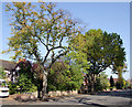
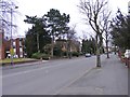
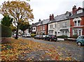
Mature trees in Albert Road, Wolverhampton
This road which links Tettenhall Road with Park Road West, has beautiful mature trees growing by the roadside for most of its length. That's the trouble; they are mature, and as they come to the end of their "safe" life, I doubt whether any which are destroyed will be replaced.
Image: © Roger D Kidd
Taken: 13 Oct 2010
0.02 miles
2
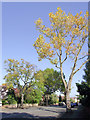
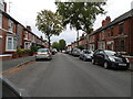
Albert Road, Wolverhampton
Looking towards West Park.
Image: © Roger D Kidd
Taken: 13 Oct 2010
0.03 miles
3
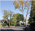
Albert Road, Wolverhampton
Near Newbridge, Albert Road links Tettenhall Road with Park Road West.
Image: © Roger D Kidd
Taken: 13 Oct 2010
0.03 miles
4
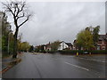
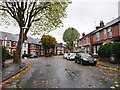
Albert Road Houses
The view in Wolverhampton on a rainy day near the West Park.
Image: © Gordon Griffiths
Taken: 25 Oct 2019
0.04 miles
5
Albert Road
The view near the Tettenhall Road in Wolverhampton.
Image: © Gordon Griffiths
Taken: 20 Mar 2016
0.04 miles
6
Avondale Road
The view along the road towards Allen Road in Wolverhampton.
Image: © Gordon Griffiths
Taken: 28 Sep 2020
0.05 miles
7
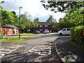
Mews View
The view of Park View Mews off Albert Road in Wolverhampton.
Image: © Gordon Griffiths
Taken: 6 Oct 2019
0.06 miles
8
Avondale Road Junction
The view of the junction with Allen Road in Wolverhampton.
Image: © Gordon Griffiths
Taken: 25 Oct 2019
0.07 miles
9
Allen Road
The view in Wolverhampton.
Image: © Gordon Griffiths
Taken: 25 Oct 2019
0.07 miles
10
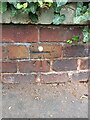
OS benchmark - Whitmore Reans, wall outside 37 Albert Road
An OS cutmark on the boundary wall of the house, which was last levelled in 1957 at 123.968m above Ordnance Datum Newlyn.
Image: © Richard Law
Taken: 24 Jul 2024
0.08 miles