IMAGES TAKEN NEAR TO
Sutherland Drive, WOLVERHAMPTON, WV5 9BB
Introduction
This page details the photographs taken nearby to Sutherland Drive, WV5 9BB by members of the Geograph project.
The Geograph project started in 2005 with the aim of publishing, organising and preserving representative images for every square kilometre of Great Britain, Ireland and the Isle of Man.

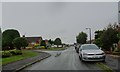
There are currently over 7.5m images from over14,400 individuals and you can help contribute to the project by visiting https://www.geograph.org.uk
Image Map
Images are licensed for reuse under creativecommons.org/licenses/by-sa/2.0
Notes
- Clicking on the map will re-center to the selected point.
- The higher the marker number, the further away the image location is from the centre of the postcode.
Image Listing (137 Images Found)
Images are licensed for reuse under creativecommons.org/licenses/by-sa/2.0
Image
Details
Distance
1
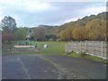
Bratch Park
The view of the play park off Bratch Lane in Wombourne.
Image: © Gordon Griffiths
Taken: 8 Nov 2018
0.05 miles
2
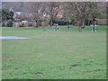
Bratch Park View
The view of the play park off Bratch Lane in Wombourne.
Image: © Gordon Griffiths
Taken: 8 Mar 2019
0.06 miles
3
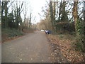
Path Parking
The view at Bratch Station on the South Staffordshire Railway Walk near Wombourne.
Image: © Gordon Griffiths
Taken: 5 Dec 2016
0.06 miles
4
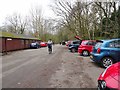
Walkers Car Park
The view at Bratch Station on the South Staffordshire Railway Walk, Wombourne.
Image: © Gordon Griffiths
Taken: 9 Mar 2020
0.06 miles
5
Strathmore Crescent
The view along the crescent by Ednam Grove in Wombourne.
Image: © Gordon Griffiths
Taken: 7 Jul 2020
0.06 miles
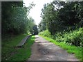
6

The South Staffordshire Railway Walk
The beginning of the former Wombourne railway station platform This was once the Wombourne Branch Line.
Image: © Bill Boaden
Taken: 22 Jun 2018
0.07 miles
7
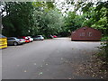
Bratch Parking
The view at Bratch Station on the South Staffordshire Railway Walk near Wombourne.
Image: © Gordon Griffiths
Taken: 21 Aug 2020
0.07 miles
8
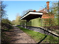
The former Wombourne (Bratch) Station
The appearance from this direction belies its current use as a popular and busy tearoom and cafe on the railway walk.
Image: © Richard Law
Taken: 27 Mar 2012
0.07 miles
9
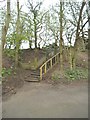
Bratch Path Steps
The view of the path steps at the Bratch car park towards Orton Lane, Wombourne.
Image: © Gordon Griffiths
Taken: 15 Apr 2016
0.07 miles
10
South Staffordshire Railway Walk - platform of former Wombourne Station, Wombourne, Staffs
The railway was a late addition to the country's rail network and opened between 1912 and 1925. It served the rural area west of Dudley. It was not a success and passenger services were withdrawn as early as 1932. It finally closed in June 1965. The walk uses about five and a half miles of the former railway route.
This view shows part of the disused Wombourne Station platform. Further along the platform, but not visible in this view, is the Railway Café, which uses the former station building.
Image: © P L Chadwick
Taken: 8 Aug 2013
0.07 miles