IMAGES TAKEN NEAR TO
The Celandines, WOLVERHAMPTON, WV5 8HZ
Introduction
This page details the photographs taken nearby to The Celandines, WV5 8HZ by members of the Geograph project.
The Geograph project started in 2005 with the aim of publishing, organising and preserving representative images for every square kilometre of Great Britain, Ireland and the Isle of Man.

There are currently over 7.5m images from over14,400 individuals and you can help contribute to the project by visiting https://www.geograph.org.uk
Image Map
Images are licensed for reuse under creativecommons.org/licenses/by-sa/2.0
Notes
- Clicking on the map will re-center to the selected point.
- The higher the marker number, the further away the image location is from the centre of the postcode.
Image Listing (136 Images Found)
Images are licensed for reuse under creativecommons.org/licenses/by-sa/2.0
Image
Details
Distance
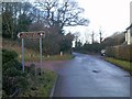
1
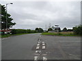
Pool House Road Junction
The view of the junction with Clap Gate Road in Wombourne.
Image: © Gordon Griffiths
Taken: 3 Jul 2020
0.05 miles
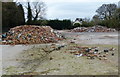
2
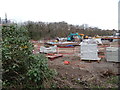
Building Site View
The view from the Staffordshire and Worcestershire Canal by the Pool House Road in Wombourne.
Image: © Gordon Griffiths
Taken: 8 Apr 2021
0.07 miles
3
The start of the Wom Brook Walk, Poolhouse Estate Section
The Wom Brook Walk runs for 2.6km through the centre of Wombourne
Image: © Keith Williams
Taken: 26 Dec 2008
0.07 miles
4
Building Site
The view from the Staffordshire and Worcestershire Canal by the Pool House Road in Wombourne.
Image: © Gordon Griffiths
Taken: 7 Jan 2021
0.07 miles
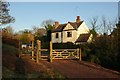
5
Derelict works site in Wombourne
Next to the Staffordshire and Worcestershire Canal.
Image: © Mat Fascione
Taken: 22 Apr 2016
0.07 miles
6
Giggetty Lane View
The view up the Lane near the Wom Brook Walk at Wombourne.
Image: © Gordon Griffiths
Taken: 24 Jan 2018
0.07 miles
7
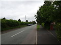
Clap Gate Road View
The view towards Bratch Common Road in Wombourne.
Image: © Gordon Griffiths
Taken: 3 Jul 2020
0.07 miles
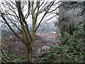
8
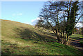
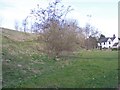
Wom Brook Walk at Giggety, Wombourne, Staffordshire
This open area and the walk way along Wom Brook to the right are now a designated Local Nature Reserve.
http://en.wikipedia.org/wiki/Wom_Brook
Image: © Roger D Kidd
Taken: 29 Jan 2010
0.08 miles
9
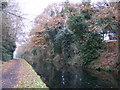
Autumn Canal
The view near Giggetty wharf on the Staffs and Worcs Canal.
Image: © Gordon Griffiths
Taken: 23 Nov 2018
0.09 miles
10
Wom Walk Scene
The view from the Wom Brook Walk at Giggetty, Wombourne.
Image: © Gordon Griffiths
Taken: 15 Mar 2018
0.09 miles