IMAGES TAKEN NEAR TO
Church Lane, WOLVERHAMPTON, WV5 7EZ
Introduction
This page details the photographs taken nearby to Church Lane, WV5 7EZ by members of the Geograph project.
The Geograph project started in 2005 with the aim of publishing, organising and preserving representative images for every square kilometre of Great Britain, Ireland and the Isle of Man.

There are currently over 7.5m images from over14,400 individuals and you can help contribute to the project by visiting https://www.geograph.org.uk
Image Map
Images are licensed for reuse under creativecommons.org/licenses/by-sa/2.0
Notes
- Clicking on the map will re-center to the selected point.
- The higher the marker number, the further away the image location is from the centre of the postcode.
Image Listing (35 Images Found)
Images are licensed for reuse under creativecommons.org/licenses/by-sa/2.0
Image
Details
Distance
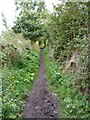
1
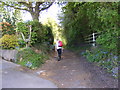
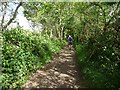
Church Lane Path
The view of the bridleway from Ebstree Road, Seisdon, Staffordshire.
Image: © Gordon Griffiths
Taken: 5 May 2017
0.03 miles
2
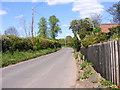
Ebstree Road
The view of the road in Seisdon, Staffordshire.
Image: © Gordon Griffiths
Taken: 5 May 2017
0.04 miles
3
Church Lane Footpath
The view of the bridleway from Ebstree Road, Seisdon, Staffordshire.
Image: © Gordon Griffiths
Taken: 22 May 2020
0.04 miles
4
Church Lane View
The view from Church Lane bridleway over Ebstree Road, Seisdon, Staffordshire.
Image: © Gordon Griffiths
Taken: 3 Feb 2022
0.05 miles
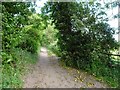
5
The narrow part of Church Lane
A narrow section of the Church Lane bridleway running just south of Tarmac's Seisdon Quarry sandpit.
Image: © Richard Law
Taken: 10 Oct 2012
0.05 miles
6
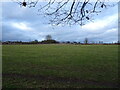
Church Lane Field
The view from Church Lane bridleway off Ebstree Road, Seisdon, Staffordshire.
Image: © Gordon Griffiths
Taken: 3 Feb 2022
0.06 miles
7
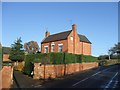
Lanes Farm
This farmhouse on Ebstree Lane dates from 1746
Image: © John M
Taken: 26 Nov 2006
0.08 miles
8
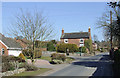
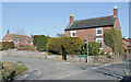
Ebstree Road, Seisdon, Staffordshire
Ahead is the junction with Post Office Road (in which there is no post office). The road leads from Seisdon to Lower Penn and Wolverhampton.
Image: © Roger D Kidd
Taken: 7 Mar 2010
0.11 miles
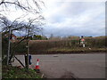
9
Post Office Road, Seisdon, Staffordshire
This is the eastern end of Post Office Road at the junction with Ebstree Road.
There is no Post Office in this road. Can a local historian contact me with information as to where it was?* The (later) post office in the village centre has also been closed since 2008.
* I have seen a 1904 map which pinpoints the post office at this junction,
to the right of this picture at what is now Roost Stables, www.wheresthepath.com gives a grid reference of SO8408294847 for the building.
Image: © Roger D Kidd
Taken: 7 Mar 2010
0.11 miles
10
Church Lane View
The view of the bridleway from Ebstree Road, Seisdon, Staffordshire.
Image: © Gordon Griffiths
Taken: 22 May 2020
0.12 miles