IMAGES TAKEN NEAR TO
Lamb Crescent, WOLVERHAMPTON, WV5 0ED
Introduction
This page details the photographs taken nearby to Lamb Crescent, WV5 0ED by members of the Geograph project.
The Geograph project started in 2005 with the aim of publishing, organising and preserving representative images for every square kilometre of Great Britain, Ireland and the Isle of Man.

There are currently over 7.5m images from over14,400 individuals and you can help contribute to the project by visiting https://www.geograph.org.uk
Image Map
Images are licensed for reuse under creativecommons.org/licenses/by-sa/2.0
Notes
- Clicking on the map will re-center to the selected point.
- The higher the marker number, the further away the image location is from the centre of the postcode.
Image Listing (69 Images Found)
Images are licensed for reuse under creativecommons.org/licenses/by-sa/2.0
Image
Details
Distance
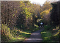
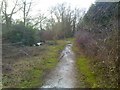
1
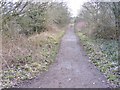
Railway Walk
The along the South Staffs Railway Walk near Wom Brook in Wombourne.
Image: © Gordon Griffiths
Taken: 16 Feb 2018
0.02 miles
2
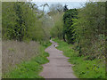
South Staffordshire Railway Walk
This is the former railway from Wolverhampton to Stourbridge Junction via Wombourne. The line was opened in 1925 and closed to passengers in 1932. The last freight train ran in June 1965. The South Staffordshire Railway Walk now runs along this former railway line.
Image: © Mat Fascione
Taken: 22 Apr 2016
0.02 miles
3
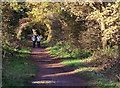
South Staffordshire Railway Walk at Wombourne
Looking north from near Common Road Bridge.
The South Staffordshire Railway Walk runs for five and a half miles from Castlecroft at the northern end to Wall Heath in the south, where it continues on to Pensnett. The northern end at Castlecroft extends through Valley Park to Oxley, Wolverhampton.
The railway was built and owned by the Great Western Railway. It was started in 1912 but not completed until 1925. There were stations at Wombourne, and at Himley with a small halt at Lower Penn.
The line was not successful. Passenger services were withdrawn by 1932. Goods traffic was carried after this date. Wounded D-Day soldiers were ferried to local hospitals briefly during World War II.
Following 1948 nationalisation the line became part of the Western Region of British Railways. Further decline in traffic throughout the 1950s and early 1960s resulted in closure following Dr Beeching's report. The last train to run on the line was on 24th June 1965.
Image: © Roger D Kidd
Taken: 11 Nov 2012
0.04 miles
4
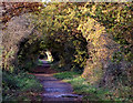
South Staffordshire Railway Walk at Wombourne
Looking north from near Common Road Bridge.
The South Staffordshire Railway Walk runs for five and a half miles from Castlecroft at the northern end to Wall Heath in the south, where it continues on to Pensnett. The northern end at Castlecroft extends through Valley Park to Oxley, Wolverhampton.
The railway was built and owned by the Great Western Railway. It was started in 1912 but not completed until 1925. There were stations at Wombourne, and at Himley with a small Halt at Lower Penn. The line was not successful.
Passenger services were withdrawn by 1932. Goods traffic was carried after this date. Wounded D-Day soldiers were ferried to local hospitals briefly during World War II.
Following 1948 nationalisation the line became part of the Western Region of British Railways. Further decline in traffic throughout the 1950s and early 1960s resulted in closure following Dr Beeching's report. The last train to run on the line was on 24th June 1965.
Image: © Roger D Kidd
Taken: 11 Nov 2012
0.04 miles
5
South Staffordshire Railway Walk at Wombourne
The South Staffordshire Railway Walk runs for five and a half miles from Castlecroft at the northern end to Wall Heath in the south, where it continues on to Pensnett. The northern end at Castlecroft extends through Valley Park to Oxley, Wolverhampton.
The railway was built and owned by the Great Western Railway.It was started in 1912 but not completed until 1925. There were stations at Wombourne, and at Himley with a small Halt at Lower Penn.
The line was not very successful. Passenger services were withdrawn in 1932. Goods traffic was carried after this date. Wounded D-Day soldiers were ferried to local hospitals briefly during World War II.
Following the 1948 nationalisation the line became part of the Western Region of British Railways. The further decline in traffic throughout the 1950s and early 1960s resulted in closure following dr Beeching's report. The last train to run on the line was on 24th June 1965.
Image: © Roger D Kidd
Taken: 11 Nov 2012
0.04 miles
6
Wom Brook View
The view from the Wom Brook Walk path on the Giggetty Estate section in Wombourne.
Image: © Gordon Griffiths
Taken: 15 Dec 2017
0.05 miles
7
Wom Brook
The view from the Wom Brook Walk path of the Giggetty Estate section in Wombourne. The brook passes in a culvert under the railway walk.
Image: © Gordon Griffiths
Taken: 12 Oct 2012
0.06 miles
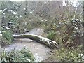
8
Wom Brook Walk
A walk along the brook off the Railway Path in Wombourne.
Image: © Gordon Griffiths
Taken: 6 Nov 2009
0.06 miles
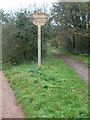
9
Wom Path
The view of the Wom Brook Walk.
Image: © Gordon Griffiths
Taken: 24 Jan 2018
0.06 miles
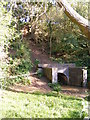
10
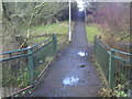
Wom Foot Bridge
The view of the Wom Brook Walk on the Giggetty Estate, Wombourne.
Image: © Gordon Griffiths
Taken: 24 Jan 2018
0.07 miles