IMAGES TAKEN NEAR TO
Lanesfield Drive, WOLVERHAMPTON, WV4 6TZ
Introduction
This page details the photographs taken nearby to Lanesfield Drive, WV4 6TZ by members of the Geograph project.
The Geograph project started in 2005 with the aim of publishing, organising and preserving representative images for every square kilometre of Great Britain, Ireland and the Isle of Man.

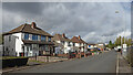
There are currently over 7.5m images from over14,400 individuals and you can help contribute to the project by visiting https://www.geograph.org.uk
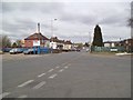
Image Map
Images are licensed for reuse under creativecommons.org/licenses/by-sa/2.0
Notes
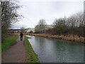
- Clicking on the map will re-center to the selected point.
- The higher the marker number, the further away the image location is from the centre of the postcode.
Image Listing (126 Images Found)
Images are licensed for reuse under creativecommons.org/licenses/by-sa/2.0
Image
Details
Distance
1
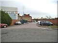
Lanesfield Drive Service Road
The view from Lanesfield Drive in Ettingshall, Wolverhampton.
Image: © Gordon Griffiths
Taken: 19 Dec 2013
0.06 miles
2
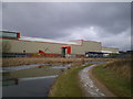
Modern distribution method meets an older network
The industrial unit is part of the premises of Baylis Distribution, a haulage firm based in the Lanesfield Industrial Estate, and they back onto this stretch of the Birmingham Canal Navigations.
Image: © Richard Law
Taken: 11 Feb 2009
0.06 miles
3
Spring Road Church
The view of the Apostolic Church in Lanesfield, Wolverhampton. The building was the former Sankey Manor Works Social Club.
Image: © Gordon Griffiths
Taken: 24 Dec 2013
0.06 miles
4
Business by the Canal
The view across the Birmingham Canal in Bilston.
Image: © Gordon Griffiths
Taken: 11 Apr 2014
0.06 miles
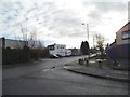
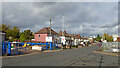
5
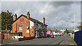
Spring Road in Lanesfield, Wolverhampton
Looking north towards Wolverhampton city centre, Spring Road is the A4126 from near Coseley, seen near the junction with Lanesfield Drive.
Image: © Roger Kidd
Taken: 25 Oct 2021
0.06 miles
6
Spring Road
The view from Lanesfield Drive in a Industrial area of Wolverhampton.
Image: © Gordon Griffiths
Taken: 4 Apr 2013
0.06 miles
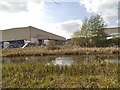
7
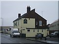
The Forgehammer, Spring Road, Lanesfield
This is in the more industrial part of Spring Road. Opposite a sheet metal fabricator. Bilston used to be dominated by the steelworks of Stewarts and Lloyds. The pub name reflects the old industries.
Image: © John M
Taken: 10 Dec 2006
0.07 miles
8
Spring Road in Lanesfield, Wolverhampton
Looking north towards Wolverhampton city centre, Spring Road is the A4126 from near Coseley, seen near the junction with Lanesfield Drive.
The Three Cups Inn on the left is a free house.
Image: © Roger Kidd
Taken: 25 Oct 2021
0.07 miles
9
Canal Bend
The view along the Birmingham Canal in Bilston.
Image: © Gordon Griffiths
Taken: 7 Jan 2022
0.07 miles
10
Spring Road in Lanesfield, Wolverhampton
Looking north towards Wolverhampton city centre, Spring Road is the A4126 from near Coseley, seen at the junction with Lanesfield Drive.
Image: © Roger Kidd
Taken: 25 Oct 2021
0.07 miles