IMAGES TAKEN NEAR TO
Genge Avenue, WOLVERHAMPTON, WV4 6SL
Introduction
This page details the photographs taken nearby to Genge Avenue, WV4 6SL by members of the Geograph project.
The Geograph project started in 2005 with the aim of publishing, organising and preserving representative images for every square kilometre of Great Britain, Ireland and the Isle of Man.

There are currently over 7.5m images from over14,400 individuals and you can help contribute to the project by visiting https://www.geograph.org.uk
Image Map
Images are licensed for reuse under creativecommons.org/licenses/by-sa/2.0
Notes
- Clicking on the map will re-center to the selected point.
- The higher the marker number, the further away the image location is from the centre of the postcode.
Image Listing (85 Images Found)
Images are licensed for reuse under creativecommons.org/licenses/by-sa/2.0
Image
Details
Distance
1

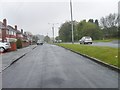
Genge Avenue
The view in Ettingshall Park, Wolverhampton.
Image: © Gordon Griffiths
Taken: 28 Feb 2012
0.02 miles
2
Wolverhampton Road East Service Road
The view alongside the A459 Wolverhampton to Sedgley road.
Image: © Gordon Griffiths
Taken: 9 May 2012
0.06 miles
3
Spring Vale Park Marker
The view of the path marker post in the park off Kenilworth Crescent, Lanesfield Wolverhampton.
Image: © Gordon Griffiths
Taken: 25 Jul 2012
0.07 miles
5
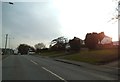
Wolverhampton Road East
The view on the A459 road to Sedgley from Wolverhampton.
Image: © Gordon Griffiths
Taken: 18 Mar 2013
0.08 miles
6
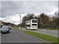
Wolverhampton's No 1 Stop
The view down Wolverhampton Road East as the Bus from the City heads towards Dudley.
Image: © Gordon Griffiths
Taken: 18 Apr 2013
0.08 miles
7
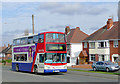
Wolverhampton Road East, The 558 to Dudley via Sedgley
Image: © Roger D Kidd
Taken: 6 Mar 2009
0.09 miles
8
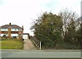
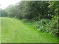
Woodland Edge
The view in Park Hill, Wolverhampton of fields and wood meeting the housing.
Image: © Gordon Griffiths
Taken: 18 Apr 2013
0.09 miles
9
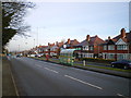
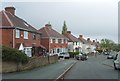
Wolverhampton Road East
The view down Wolverhampton Road East, including postbox WV4 379.
Compare this image with Image, which would have been taken from almost exactly the same place, a mere 42 years ago.
Image: © Richard Law
Taken: 14 Jan 2009
0.09 miles
10
Spring Vale Park Sign
The park off Kenilworth Crescent, Lanesfield Wolverhampton.
Image: © Gordon Griffiths
Taken: 25 Jul 2012
0.10 miles