IMAGES TAKEN NEAR TO
Kenilworth Crescent, WOLVERHAMPTON, WV4 6SD
Introduction
This page details the photographs taken nearby to Kenilworth Crescent, WV4 6SD by members of the Geograph project.
The Geograph project started in 2005 with the aim of publishing, organising and preserving representative images for every square kilometre of Great Britain, Ireland and the Isle of Man.

There are currently over 7.5m images from over14,400 individuals and you can help contribute to the project by visiting https://www.geograph.org.uk
Image Map
Images are licensed for reuse under creativecommons.org/licenses/by-sa/2.0
Notes
- Clicking on the map will re-center to the selected point.
- The higher the marker number, the further away the image location is from the centre of the postcode.
Image Listing (82 Images Found)
Images are licensed for reuse under creativecommons.org/licenses/by-sa/2.0
Image
Details
Distance
1
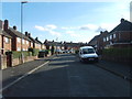
Moreton Avenue View
The view in Lanesfield, Wolverhampton.
Image: © Gordon Griffiths
Taken: 30 Oct 2012
0.01 miles
2
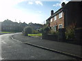
Kenilworth Crescent Bend
The view in Lanesfield, Wolverhampton.
Image: © Gordon Griffiths
Taken: 30 Oct 2012
0.04 miles
4

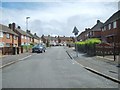
Crabtree Close
The view down the Close alongside the Birmingham New Road (A4123) at Lanesfield. The Close is named after the Electrical Factory which stood on this site.
Image: © Gordon Griffiths
Taken: 10 Jul 2012
0.07 miles
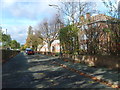
5
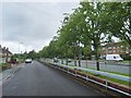
Service Road View
The view down the service road alongside the Birmingham New Road (A4123) at Lanesfield.
Image: © Gordon Griffiths
Taken: 10 Jul 2012
0.07 miles
6
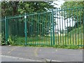
School View
The view off Kenilworth Crescent, Lanesfield Wolverhampton. The railings are the fence around Spring Vale Primary sports field.
Image: © Gordon Griffiths
Taken: 25 Jul 2012
0.07 miles
7

Spring Vale Primary
The School off Moreton Avenue at Lanesfield.
Image: © Gordon Griffiths
Taken: 10 Jul 2012
0.08 miles
8
A4123 Flats Service Road
The view down the Flats service road alongside the Birmingham New Road (A4123) at Lanesfield.
Image: © Gordon Griffiths
Taken: 30 Oct 2012
0.09 miles
9

Birmingham New Road Flats
The view down the service road alongside the Birmingham New Road (A4123) at Lanesfield.
Image: © Gordon Griffiths
Taken: 30 Oct 2012
0.09 miles
10
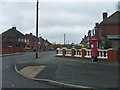
Beverley Crescent Post Box
The view in Ettingshall Park, Wolverhampton.
Image: © Gordon Griffiths
Taken: 25 Oct 2012
0.09 miles