IMAGES TAKEN NEAR TO
Birmingham New Road, WOLVERHAMPTON, WV4 6RX
Introduction
This page details the photographs taken nearby to Birmingham New Road, WV4 6RX by members of the Geograph project.
The Geograph project started in 2005 with the aim of publishing, organising and preserving representative images for every square kilometre of Great Britain, Ireland and the Isle of Man.

There are currently over 7.5m images from over14,400 individuals and you can help contribute to the project by visiting https://www.geograph.org.uk
Image Map (Loading...)


Getting Data...Please wait
Leaflet Map data © OpenStreetMap
Images are licensed for reuse under creativecommons.org/licenses/by-sa/2.0
Notes
- Clicking on the map will re-center to the selected point.
- The higher the marker number, the further away the image location is from the centre of the postcode.
Image Listing (110 Images Found)
Images are licensed for reuse under creativecommons.org/licenses/by-sa/2.0
Image
Details
Distance
1

A4123 immediately north of Parkfield Road
Image: © Peter Whatley
Taken: 22 Oct 2008
0.02 miles
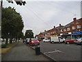
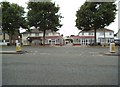
2
New Road Bus Stop View
The view of the Birmingham New Road (A4123) in Parkfield Wolverhampton, the wasteland in the background was a petrol station.
Image: © Gordon Griffiths
Taken: 27 Jul 2013
0.03 miles
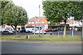
3
New Road Shops
The view on the Birmingham New Road in Parkfield, Wolverhampton.
Image: © Gordon Griffiths
Taken: 27 Jul 2013
0.04 miles
4

School Sports Field
The view into the former Parkfield High School off Lawnswood Avenue. The school changed to the SWB Academy and has now moved to Bilston.
Image: © Gordon Griffiths
Taken: 1 Aug 2013
0.04 miles
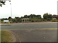
6

Overgrown Station
The view of the former Petrol Station off the Birmingham New Road in Parkfield, Wolverhampton.
Image: © Gordon Griffiths
Taken: 1 Aug 2013
0.05 miles
7
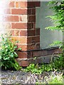
OS benchmark - Parkfield, no 23 Birmingham New Road
An OS cutmark in the bricks of No 23 Birmingham New Road; originally levelled at 153.884m above Ordnance Datum Newlyn.
Image: © Richard Law
Taken: 13 Aug 2013
0.06 miles
8
The Grove
The view of the Close off the Birmingham New Road (A4123) in Parkfield, Wolverhampton.
Image: © Gordon Griffiths
Taken: 27 Jul 2013
0.07 miles
9
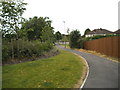
New Road Path
The view of the path to the Birmingham New Road in Parkfield, Wolverhampton.
Image: © Gordon Griffiths
Taken: 27 Jul 2013
0.07 miles
10
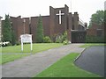
St Teresa's Church
This Roman Catholic Church stands on the Birmingham New Road at Parkfield.
Image: © Gordon Griffiths
Taken: 8 Jun 2007
0.08 miles