IMAGES TAKEN NEAR TO
Norbury Crescent, WOLVERHAMPTON, WV4 6DJ
Introduction
This page details the photographs taken nearby to Norbury Crescent, WV4 6DJ by members of the Geograph project.
The Geograph project started in 2005 with the aim of publishing, organising and preserving representative images for every square kilometre of Great Britain, Ireland and the Isle of Man.

There are currently over 7.5m images from over14,400 individuals and you can help contribute to the project by visiting https://www.geograph.org.uk
Image Map
Images are licensed for reuse under creativecommons.org/licenses/by-sa/2.0
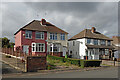
Notes
- Clicking on the map will re-center to the selected point.
- The higher the marker number, the further away the image location is from the centre of the postcode.
Image Listing (114 Images Found)
Images are licensed for reuse under creativecommons.org/licenses/by-sa/2.0
Image
Details
Distance
1
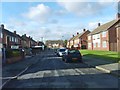
Norbury Crescent
The view in Lanesfield, Wolverhampton.
Image: © Gordon Griffiths
Taken: 30 Oct 2012
0.02 miles
2
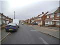
Norbury Crescent View
The view in Ettingshall, Wolverhampton.
Image: © Gordon Griffiths
Taken: 19 Dec 2013
0.03 miles
3
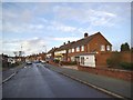
Hilton Road Shops
The view of the Shops in Lanesfield, Wolverhampton.
Image: © Gordon Griffiths
Taken: 24 Dec 2013
0.06 miles
4
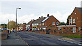
Hilton Road in Lanesfield, Wolverhampton
Looking north-west from the junction with Florence Avenue.
Image: © Roger Kidd
Taken: 25 Oct 2021
0.07 miles
5
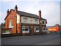
The Three Cups pub
This pub sits on Spring Road, Ettingshall.
My guess is that the name somehow is related to the old forging and smelting industries of this part of the Black Country - something to do with the processes of melting metal?
Image: © Richard Law
Taken: 5 Mar 2009
0.07 miles
6
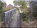
Hilton Brook Footbridge
The bridge to Hilton Hall Community Centre playing field in Lanesfield, Wolverhampton.
Image: © Gordon Griffiths
Taken: 8 Nov 2012
0.07 miles
7
Hilton Road and Norbury Crescent in Lanesfield, Wolverhampton
Looking north across Hilton Road towards Norbury Crescent. Off to the left is Florence Avenue.
Image: © Roger Kidd
Taken: 25 Oct 2021
0.07 miles
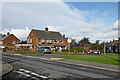
8
Housing in Lanesfield, Wolverhampton
Looking north-west along Hilton Road from the junction with Florence Avenue.
Image: © Roger Kidd
Taken: 25 Oct 2021
0.07 miles
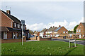
9
Houses in Spring Road, Lanesfield, Wolverhampton
There is a row of eight semi-detached houses here in this mixed industrial and residential area.
Image: © Roger Kidd
Taken: 25 Oct 2021
0.08 miles
10
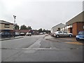
Spring Road Estate
The view down the small Industrial Estate in Ettingshall, Wolverhampton.
Image: © Gordon Griffiths
Taken: 17 Sep 2013
0.08 miles