IMAGES TAKEN NEAR TO
Wolverhampton Road East, WOLVERHAMPTON, WV4 6AT
Introduction
This page details the photographs taken nearby to Wolverhampton Road East, WV4 6AT by members of the Geograph project.
The Geograph project started in 2005 with the aim of publishing, organising and preserving representative images for every square kilometre of Great Britain, Ireland and the Isle of Man.

There are currently over 7.5m images from over14,400 individuals and you can help contribute to the project by visiting https://www.geograph.org.uk
Image Map
Images are licensed for reuse under creativecommons.org/licenses/by-sa/2.0
Notes
- Clicking on the map will re-center to the selected point.
- The higher the marker number, the further away the image location is from the centre of the postcode.
Image Listing (138 Images Found)
Images are licensed for reuse under creativecommons.org/licenses/by-sa/2.0
Image
Details
Distance
1
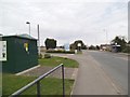
Wolverhampton Border
The view from Beacon Centre for the Blind alongside the Wolverhampton Road (A459), on the Wolverhampton Dudley border.
Image: © Gordon Griffiths
Taken: 25 Apr 2013
0.02 miles
2
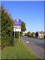
Welcome to Wolverhampton
The view from near the Beacon Centre alongside the Wolverhampton Road(A459), on the Wolverhampton Dudley border.
Image: © Gordon Griffiths
Taken: 9 Oct 2018
0.02 miles
3
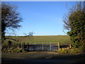
Field off Wolverhampton Road East, Ettingshall Park
Located somewhat incongruously off a main road in the urban West Midlands.
Image: © Richard Vince
Taken: 29 Dec 2013
0.03 miles
4
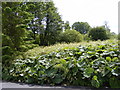
Rodway Close View
The heavily overgrown land between Ettingshall Park Estate and Sedgley Beacon. The plants at the front appear to be Rhubarb.
Image: © Gordon Griffiths
Taken: 4 Jun 2009
0.04 miles
5
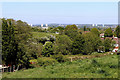
View from near Ettingshall Park, Wolverhampton
This is the view seen by looking north-north-west from the track leading up Beacon Hill, about two hundred metres up from Wolverhampton Road.
In the distance are the four tower blocks in Heath Town, the chimney of New Cross Hoapital's incinerator, and the three tower blocks in Wednesfield. The high ground beyond the hospital is Cannock Chase.
Image: © Roger Kidd
Taken: 6 May 2020
0.05 miles
6
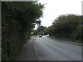
Wolverhampton Road East (A459)
Towards Sedgley.
Image: © JThomas
Taken: 22 Aug 2019
0.05 miles
7
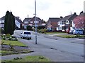
Farrington Road Bend
The view on Wolverhampton's Ettingshall Park Estate.
Image: © Gordon Griffiths
Taken: 24 Apr 2012
0.06 miles
8
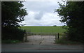
Field entrance off Wolverhampton Road East (A459)
Image: © JThomas
Taken: 22 Aug 2019
0.06 miles
9
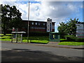
Beacon Centre
The view of the Beacon Centre for the blind on the Wolverhampton Sedgley border.
The view of the old building in November 2006 Image
Image: © Gordon Griffiths
Taken: 29 Sep 2021
0.07 miles
10
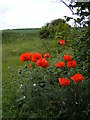
Wolverhampton Road East Poppies
Poppies in a field alongside the busy A459, on the Wolverhampton Dudley border.
Image: © Gordon Griffiths
Taken: 4 Jun 2009
0.07 miles