IMAGES TAKEN NEAR TO
Rebecca Gardens, WOLVERHAMPTON, WV4 5PR
Introduction
This page details the photographs taken nearby to Rebecca Gardens, WV4 5PR by members of the Geograph project.
The Geograph project started in 2005 with the aim of publishing, organising and preserving representative images for every square kilometre of Great Britain, Ireland and the Isle of Man.

There are currently over 7.5m images from over14,400 individuals and you can help contribute to the project by visiting https://www.geograph.org.uk
Image Map
Images are licensed for reuse under creativecommons.org/licenses/by-sa/2.0
Notes
- Clicking on the map will re-center to the selected point.
- The higher the marker number, the further away the image location is from the centre of the postcode.
Image Listing (381 Images Found)
Images are licensed for reuse under creativecommons.org/licenses/by-sa/2.0
Image
Details
Distance
1
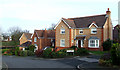
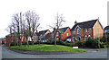
Modern Housing, Penn, Wolverhampton
These attractive, if rather densely built, houses were erected in the 1980s following the demolition and sale of Manor Road School (Colton Hills Lower School Annexe) and its playing fields.
Image: © Roger D Kidd
Taken: 1 Feb 2008
0.02 miles
2
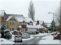
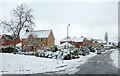
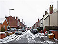
Attractive housing in Penn, Wolverhampton
Although they are rather close together, the houses on this estate (built in the 1980s on the former Colton Hills School Annexe site) are attractively varied in character. The late March snow was part of the coldest March since 1962.
Image: © Roger D Kidd
Taken: 24 Mar 2013
0.03 miles
3
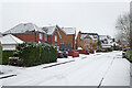
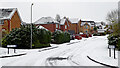
Amanda Avenue in Penn, Wolverhampton
Looking south-west from near the junction with Manor Road. Housing here is from the 1980s, and is on land formerly occupied by Colton Hills Lower School (Annexe).
Image: © Roger Kidd
Taken: 2 Jan 2021
0.04 miles
4
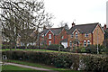
Amanda Avenue in Penn, Wolverhampton
Looking south-south-west from Manor Road. Housing here is from the 1980s, and is on land formerly occupied by Colton Hills Lower School (Annexe).
Image: © Roger Kidd
Taken: 2 Jan 2021
0.04 miles
5
Modern Housing, Penn, Wolverhampton
At the junction of Manor Road and Amanda Avenue, these attractive dwellings were built in the 1990s on the former site of Colton Hills Lower School (Annexe).
Image: © Roger D Kidd
Taken: 1 Feb 2008
0.04 miles
6
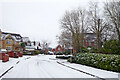
Amanda Avenue in Penn, Wolverhampton
Late March snow here was part of the coldest March since 1962. The housing is on the site of the former Colton Hills Lower School.
Image: © Roger D Kidd
Taken: 24 Mar 2013
0.05 miles
7
Amanda Avenue in Penn, Wolverhampton
Looking south-south-west from Manor Road. Housing here is from the 1980s, and is on land formerly occupied by Colton Hills Lower School (Annexe).
Image: © Roger Kidd
Taken: 2 Jan 2021
0.05 miles
8

Housing in Penn, Wolverhampton
Looking south across Manor Road from Muchall Park near the medical centre, the housing is in Virginia Drive, and was built in the 1990s on the former grounds of Colton Hills Lower School (annexe), previously Penn Secondary Modern School.
Image: © Roger Kidd
Taken: 15 Mar 2011
0.06 miles
9
Housing in Virginia Drive, Penn, Wolverhampton
The view looking south-east across Manor Road from Muchall Park. The houses were built in the 1990s on the former grounds of Colton Hills Lower School (annexe) previously Penn Secondary Modern School.
Image: © Roger Kidd
Taken: 15 Mar 2011
0.06 miles
10
Swan Bank in Penn, Wolverhampton
Looking south-east towards Wakeley Hill, from the junction with Manor Road.
Image: © Roger Kidd
Taken: 2 Jan 2021
0.06 miles