IMAGES TAKEN NEAR TO
Foxlands Crescent, WOLVERHAMPTON, WV4 5ND
Introduction
This page details the photographs taken nearby to Foxlands Crescent, WV4 5ND by members of the Geograph project.
The Geograph project started in 2005 with the aim of publishing, organising and preserving representative images for every square kilometre of Great Britain, Ireland and the Isle of Man.

There are currently over 7.5m images from over14,400 individuals and you can help contribute to the project by visiting https://www.geograph.org.uk
Image Map
Images are licensed for reuse under creativecommons.org/licenses/by-sa/2.0
Notes
- Clicking on the map will re-center to the selected point.
- The higher the marker number, the further away the image location is from the centre of the postcode.
Image Listing (72 Images Found)
Images are licensed for reuse under creativecommons.org/licenses/by-sa/2.0
Image
Details
Distance
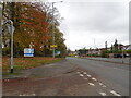
1
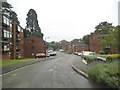
Foxlands Crescent
The view in Spring Hill, Penn Staffordshire near the Wolverhampton border.
Image: © Gordon Griffiths
Taken: 14 Aug 2015
0.02 miles
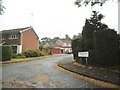
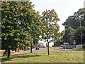
2
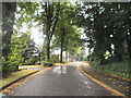
Foxlands Crescent View
The view in Spring Hill, Penn Staffordshire near the Wolverhampton border.
Image: © Gordon Griffiths
Taken: 14 Aug 2015
0.04 miles
3
Foxlands Crescent Scene
The view in Spring Hill, Penn, Staffordshire near the Wolverhampton border.
Image: © Gordon Griffiths
Taken: 5 Feb 2021
0.06 miles
4
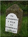
Old Milestone by the A449, Stourbridge Road, Wombourne Parish
Metal plate attached to stone post by the A449, in parish of WOMBOURNE (SOUTH STAFFORDSHIRE District), Stourbridge Road, Lloyd Hill, by traffic roundabout, North of Lloyd Farm, on grass verge on East side of road. Wolverhampton iron plate, erected by the Streetway & Wordsley Green turnpike trust in the 19th century.
Inscription reads:-
TO
W.HAMPTON
3 MILES
TO
STOURBRIDGE
7 MILES
Milestone Society National ID: ST_WVSB03
Image: © Mike Faherty
Taken: 12 Oct 2006
0.10 miles
5
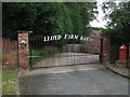
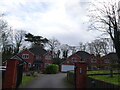
Private drive to Lloyd Farm Barns
Off the A449.
Image: © JThomas
Taken: 22 Aug 2019
0.10 miles
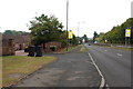
6
Chandler Drive
The view from Foxlands Drive in Spring Hill, Penn, Staffordshire near the Wolverhampton border.
Image: © Gordon Griffiths
Taken: 14 Aug 2015
0.11 miles
7
A449 Dual Carriageway, Stourbridge Road
Lloyd House Barns are on the left, the barns have been converted to housing.
Image: © Mick Malpass
Taken: 25 Aug 2011
0.11 miles
8
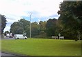
A449 Island
The view on the Stourbridge Road in Lower Penn on the Wolverhampton border.
Image: © Gordon Griffiths
Taken: 22 Sep 2017
0.11 miles
9
Island Approach
The view down the A449 Penn Road from Foxlands Drive in Spring Hill, Penn, Staffordshire near the Wolverhampton border.
Image: © Gordon Griffiths
Taken: 4 Nov 2020
0.12 miles
10
Stourbridge Road just before it becomes Penn Road
Image: © Row17
Taken: 6 Sep 2012
0.12 miles