IMAGES TAKEN NEAR TO
Foxlands Drive, WOLVERHAMPTON, WV4 5NB
Introduction
This page details the photographs taken nearby to Foxlands Drive, WV4 5NB by members of the Geograph project.
The Geograph project started in 2005 with the aim of publishing, organising and preserving representative images for every square kilometre of Great Britain, Ireland and the Isle of Man.

There are currently over 7.5m images from over14,400 individuals and you can help contribute to the project by visiting https://www.geograph.org.uk
Image Map
Images are licensed for reuse under creativecommons.org/licenses/by-sa/2.0
Notes
- Clicking on the map will re-center to the selected point.
- The higher the marker number, the further away the image location is from the centre of the postcode.
Image Listing (80 Images Found)
Images are licensed for reuse under creativecommons.org/licenses/by-sa/2.0
Image
Details
Distance
1
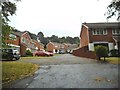
Foxlands Drive Close
The view from Foxlands Drive in Spring Hill, Penn, Staffordshire near the Wolverhampton border.
Image: © Gordon Griffiths
Taken: 14 Aug 2015
0.01 miles
3
Chandler Drive
The view from Foxlands Drive in Spring Hill, Penn, Staffordshire near the Wolverhampton border.
Image: © Gordon Griffiths
Taken: 14 Aug 2015
0.03 miles
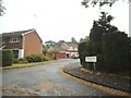
4
Foxlands Drive Scene
The view down the A449 from Foxlands Drive in Spring Hill, Penn, Staffordshire near the Wolverhampton border.
Image: © Gordon Griffiths
Taken: 14 Aug 2015
0.04 miles
5
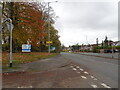
Island Approach
The view down the A449 Penn Road from Foxlands Drive in Spring Hill, Penn, Staffordshire near the Wolverhampton border.
Image: © Gordon Griffiths
Taken: 4 Nov 2020
0.06 miles
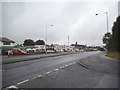
6
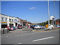
Car park and shops, Springhill Lane, Penn
This row of shops stands at the east end of Springhill Lane, where it meets Penn Road on the southern boundary of Wolverhampton (note the "Welcome..." sign behind the Give Way sign on the right). The small car park was once a turning area for trolleybuses, which described a fairly gentle pear shape to turn in this road junction. Traces of a later bus turning circle, presumably installed when Penn Road became a dual carriageway, are slowly being eradicated by realignments to the pavement. Buses have not normally terminated here since the early 1990s, and when they did, latterly they turned using the large roundabout just over the boundary into South Staffordshire.
Image: © Richard Vince
Taken: 4 Jun 2013
0.06 miles
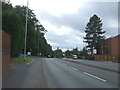
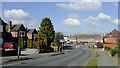
7
Stourbridge Road just before it becomes Penn Road
Image: © Row17
Taken: 6 Sep 2012
0.07 miles
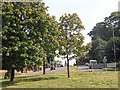
8
Buttons Farm Road View
The view in Penn, Wolverhampton.
Image: © Gordon Griffiths
Taken: 22 Dec 2020
0.07 miles
9

Springhill Lane Shops
The view from Braden Road in Spring Hill, Wolverhampton
Image: © Gordon Griffiths
Taken: 12 Aug 2020
0.08 miles
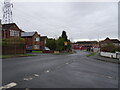
10
Buttons Farm Road, Spring Hill, Wolverhampton
This is looking north-west from the junction with Holden Road, towards the dual carriageway Penn Road/Stourbridge Road (A449).
Image: © Roger D Kidd
Taken: 9 Mar 2010
0.08 miles