IMAGES TAKEN NEAR TO
Penn Common Road, WOLVERHAMPTON, WV4 5JU
Introduction
This page details the photographs taken nearby to Penn Common Road, WV4 5JU by members of the Geograph project.
The Geograph project started in 2005 with the aim of publishing, organising and preserving representative images for every square kilometre of Great Britain, Ireland and the Isle of Man.

There are currently over 7.5m images from over14,400 individuals and you can help contribute to the project by visiting https://www.geograph.org.uk
Image Map
Images are licensed for reuse under creativecommons.org/licenses/by-sa/2.0
Notes
- Clicking on the map will re-center to the selected point.
- The higher the marker number, the further away the image location is from the centre of the postcode.
Image Listing (201 Images Found)
Images are licensed for reuse under creativecommons.org/licenses/by-sa/2.0
Image
Details
Distance
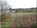
1
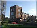
Lloyd Roberts Buildings on Penn Common
This building was once the Sedgley Brewery. The brewery closed in the early 1900s as it could not compete with the newer mechanised facilities.
Image: © John M
Taken: 2 Dec 2006
0.01 miles
3
Sedgley Road
The Road across Penn Common, snow clouds in view.
Image: © Gordon Griffiths
Taken: 27 Oct 2008
0.02 miles
4
Houses by Lloyd Roberts buildings on Penn Common
Viewed from Penn Common Road, looking east.
Image: © Roger Kidd
Taken: 29 Mar 2021
0.02 miles
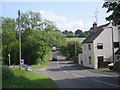
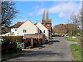
5
Penn Common Road Cottages
The view on Penn Common, Staffordshire.
Image: © Gordon Griffiths
Taken: 9 Mar 2021
0.03 miles
6
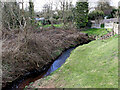
Penn Brook by Penn Common in Staffordshire
Looking west (downstream) from the Penn Road bridge near Penn Croft Lane.
Penn Brook rises about a mile to the north-east on Park Hill near Goldthorn Park. It flows south-west towards Wombourne, having changed its name to Wom Brook, then on to join the Smestow Brook.
Image: © Roger Kidd
Taken: 29 Mar 2021
0.03 miles
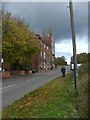
7
Sedgley Road approaching Penn Common, Staffordshire
Looking north-north-west towards Penn, this is where Penn Road changes to Sedgley Road.
Image: © Roger Kidd
Taken: 29 Mar 2021
0.03 miles
8
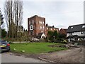
Lloyd Roberts Building
A view of the Penn Common building which was once the Sedgley Brewery, the brewery closed in the early 1900s.
The view in December 2006 Image
Image: © Gordon Griffiths
Taken: 9 Mar 2021
0.04 miles
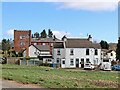
9
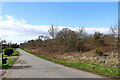
Penn Common Road in South Staffordshire
Looking south-west from the junction with Sedgley Road.
Off to the right, much of Penn Common has been used as a golf course since 1892-1893. There are still many well managed attractive woodland areas and some patches of sandy heathland.
Image: © Roger Kidd
Taken: 29 Mar 2021
0.04 miles
10

Houses by Lloyd Roberts buildings on Penn Common, Staffordshire
Viewed from Penn Common Road, looking east towards Sedgley Road.
Image: © Roger Kidd
Taken: 29 Mar 2021
0.04 miles