IMAGES TAKEN NEAR TO
Ward Road, WOLVERHAMPTON, WV4 5DL
Introduction
This page details the photographs taken nearby to Ward Road, WV4 5DL by members of the Geograph project.
The Geograph project started in 2005 with the aim of publishing, organising and preserving representative images for every square kilometre of Great Britain, Ireland and the Isle of Man.

There are currently over 7.5m images from over14,400 individuals and you can help contribute to the project by visiting https://www.geograph.org.uk
Image Map (Loading...)


Getting Data...Please wait
Leaflet Map data © OpenStreetMap
Images are licensed for reuse under creativecommons.org/licenses/by-sa/2.0
Notes
- Clicking on the map will re-center to the selected point.
- The higher the marker number, the further away the image location is from the centre of the postcode.
Image Listing (170 Images Found)
Images are licensed for reuse under creativecommons.org/licenses/by-sa/2.0
Image
Details
Distance
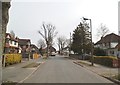
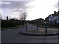
1
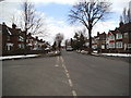
Ward Road
The snowy spring view on Goldthorn Park, Wolverhampton.
Image: © Gordon Griffiths
Taken: 28 Mar 2013
0.03 miles
2
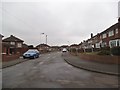
Neville Avenue Scene
The view on the Goldthorn Estate in Wolverhampton.
Image: © Gordon Griffiths
Taken: 20 Mar 2013
0.04 miles
3
Neville Avenue
The view on the Goldthorn Estate in Wolverhampton.
Image: © Gordon Griffiths
Taken: 20 Mar 2013
0.05 miles
4
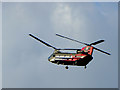
Chinook over Wolverhampton
At around 18:30 GMT this helicopter spent about fifteen minutes circling around the Goldthorn Park/Blakenhall area of Wolverhampton.
Image: © Roger D Kidd
Taken: 9 Jun 2015
0.06 miles
5
Honor Avenue View
The view in Blakenhall Wolverhampton, on the Goldthorn Park Estate.
Image: © Gordon Griffiths
Taken: 7 Apr 2013
0.07 miles
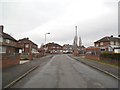
6
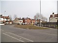
Ward Road Junction
The view in Blakenhall Wolverhampton, looking down the A4039 Goldthorn Hill.
Image: © Gordon Griffiths
Taken: 7 Apr 2013
0.07 miles
7
Longdon Avenue
The view on the Goldthorn Estate in Wolverhampton.
Image: © Gordon Griffiths
Taken: 20 Mar 2013
0.08 miles
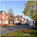
8
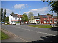
North end of Ward Road, Goldthorn Park
The wide grass verges on the corners of Ward Road and Goldthorn Hill Road give a clue to the former shape of this junction. In 1949, the Fighting Cocks to Willenhall trolleybus route was diverted here from Image to ease congestion in the latter turning circle, the wide mouth of Ward Road being sufficiently spacious to turn a bus. This remained a terminus for the same route and its successors until (if memory serves) 1993, when the 527 (Fighting Cocks to Ashmore Park via Bilston and Willenhall) was extended from both ends to Wolverhampton town centre to form a circular route. However, until the junction was rebuilt in its present form some years later, the westbound bus stop remained on the western corner of Ward Road (close to where a black litter bin can be discerned in this picture).
Image: © Richard Vince
Taken: 3 Jun 2013
0.08 miles
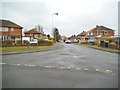
9
Ward Road Island
The view in Goldthorn Park, Wolverhampton.
Image: © Gordon Griffiths
Taken: 31 Jan 2013
0.08 miles
10
Goldthorn Hill approaching Fighting Cocks, Wolverhampton
This is the A4039 from Penn to Bilston. Ahead is the crossroads with the A459 (Wolverhampton-Dudley) named after the public house which formerly occupied the site now used by Aldi. Some early twentieth century semi-detached houses have "lost" their chimney stacks, while others have no remaining chimney pots. This road is jammed with traffic regularly on weekdays between 8:00 and 9:00, and 15:30 and 18:00.
Image: © Roger D Kidd
Taken: 31 Oct 2015
0.08 miles