IMAGES TAKEN NEAR TO
Rosemary Crescent, WOLVERHAMPTON, WV4 5BS
Introduction
This page details the photographs taken nearby to Rosemary Crescent, WV4 5BS by members of the Geograph project.
The Geograph project started in 2005 with the aim of publishing, organising and preserving representative images for every square kilometre of Great Britain, Ireland and the Isle of Man.

There are currently over 7.5m images from over14,400 individuals and you can help contribute to the project by visiting https://www.geograph.org.uk
Image Map
Images are licensed for reuse under creativecommons.org/licenses/by-sa/2.0
Notes
- Clicking on the map will re-center to the selected point.
- The higher the marker number, the further away the image location is from the centre of the postcode.
Image Listing (157 Images Found)
Images are licensed for reuse under creativecommons.org/licenses/by-sa/2.0
Image
Details
Distance
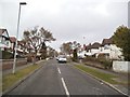
1
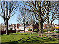
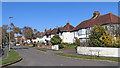
Rosemary Crescent in Goldthorn Park, Wolverhampton
Looking west-north-west from Ednam Road.
Image: © Roger Kidd
Taken: 25 Mar 2020
0.02 miles
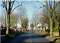
2
Rosemary Crescent in Goldthorn Park, Wolverhampton
Looking east from the northern end of Jeremy Road. Note: this is NOT Rosemary Crescent West.
Image: © Roger Kidd
Taken: 25 Mar 2020
0.04 miles
3
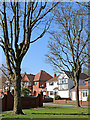
Housing in Rosemary Crescent, Goldthorn Park, Wolverhampton
Looking north-west from Ednam Road.
Note: this is NOT Rosemary Crescent West.
Image: © Roger Kidd
Taken: 25 Mar 2020
0.04 miles
4
Rosemary Crescent
The view in Goldthorn Park, Wolverhampton.
Image: © Gordon Griffiths
Taken: 19 Jun 2012
0.04 miles
5
Rosemary Crescent in Goldthorn Park, Wolverhampton
Looking east from the northern end of Jeremy Road. Note: this is NOT Rosemary Crescent West.
Image: © Roger Kidd
Taken: 25 Mar 2020
0.04 miles
6
Rosemary Crescent in Goldthorn Park, Wolverhampton
Looking east from the northern end of Jeremy Road. Note: this is NOT Rosemary Crescent West.
Image: © Roger Kidd
Taken: 25 Mar 2020
0.04 miles
7
Rosemary Crescent View
The view in towards Ednam Road bus stop in Goldthorn Park, Wolverhampton.
Image: © Gordon Griffiths
Taken: 19 Jun 2012
0.05 miles
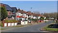
8
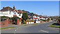
Road Junction on Goldthorn Park Estate, Wolverhampton
This is Rosemary Avenue as it approaches the roundabout at the junction with Ednam Road (left and right) and Honor Avenue (ahead).
Goldthorn Park Estate was built in the 1920s and consisted of 1,500-2,000 houses, built in a setting of woods and scattered spinneys. The original plans included bowling greens, croquet lawns and an 18-hole golf course, though none of these were ever built. The houses on the estate included four bedroomed houses for the medium sized family, three bedroom houses, which were given what the architect called "cottage treatment", and the "servantless House". All houses had separate kitchens and bathrooms, and some even had a garage. ( text adapted from The History of Wolverhampton http://www.wolverhamptonhistory.org.uk/politics/houses/development2/index.html?sid=05ad46fcc373d91968a2dc95b4e31032 )
Image: © Roger D Kidd
Taken: 27 Nov 2010
0.06 miles
9
Rosemary Avenue
The view on the Goldthorn Estate in Wolverhampton.
Image: © Gordon Griffiths
Taken: 20 Mar 2013
0.06 miles
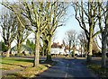
10
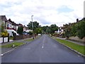
Ednam Road, Goldthorn Park, Wolverhampton
Approaching the roundabout junction with Rosemary Crescent (left) and Honor Avenue (right).
Goldthorn Park Estate was built in the 1920s and consisted of 1,500-2,000 houses, built in a setting of woods and scattered spinneys. The original plans included bowling greens, croquet lawns and an 18-hole golf course, though none of these were ever built. The houses on the estate included four bedroomed houses for the medium sized family, three bedroom houses, which were given what the architect called the 'cottage treatment', and the 'servantless house'. All houses had separate kitchens and bathrooms, and some even had a garage.
(text adapted from The History of Wolverhampton http://www.wolverhamptonhistory.org.uk/politics/houses/development2/index.html?sid=05ad46fcc373d91968a2dc95b4e31032 )
Image: © Roger D Kidd
Taken: 27 Nov 2010
0.06 miles