IMAGES TAKEN NEAR TO
Lower Penn, WOLVERHAMPTON, WV4 4XL
Introduction
This page details the photographs taken nearby to WV4 4XL by members of the Geograph project.
The Geograph project started in 2005 with the aim of publishing, organising and preserving representative images for every square kilometre of Great Britain, Ireland and the Isle of Man.

There are currently over 7.5m images from over14,400 individuals and you can help contribute to the project by visiting https://www.geograph.org.uk
Image Map
Images are licensed for reuse under creativecommons.org/licenses/by-sa/2.0
Notes
- Clicking on the map will re-center to the selected point.
- The higher the marker number, the further away the image location is from the centre of the postcode.
Image Listing (54 Images Found)
Images are licensed for reuse under creativecommons.org/licenses/by-sa/2.0
Image
Details
Distance
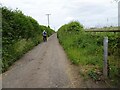
1
Pool Hall Lane
The Lane is part of the Monarch's Way.
Image: © Gordon Griffiths
Taken: 6 Jun 2007
0.01 miles
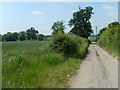
2
Pool Hall Path
The view along the Monarch's Way path to Pool Hall near Trescott.
Image: © Gordon Griffiths
Taken: 24 Jun 2021
0.04 miles
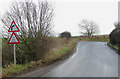
3
Furnace Grange Road towards the A454
Unfortunately for some via a deep ford.
Image: © JThomas
Taken: 8 Jun 2019
0.06 miles
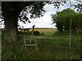
4
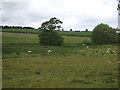
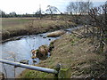
Grazing near Trescott
Looking down to the Smestow Brook.
Image: © JThomas
Taken: 8 Jun 2019
0.06 miles
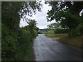
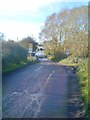
5
Furnace Grange Road, Trescott, Staffordshire
The slope up from Trescott Ford, where the Smestow Brook crosses the road to Seisdon, Lower Penn and Ebstree.
Image: © Roger D Kidd
Taken: 21 Jan 2009
0.08 miles
7
Ford Scene
The view down Furnace Grange Road of Trescott Ford and Smestow Brook looking towards the Bridgnorth Road.
Image: © Gordon Griffiths
Taken: 24 Oct 2018
0.09 miles
8
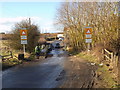
Ford View
The view down Furnace Grange Road of Trescott Ford and Smestow Brook looking towards the Bridgnorth Road.
Image: © Gordon Griffiths
Taken: 17 Feb 2015
0.09 miles
9
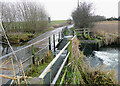
View from Footbridge
Smestow Brook from Ford Footbridge.
Image: © Gordon Griffiths
Taken: 25 Jan 2008
0.09 miles
10
Smestow Brook flowing over Trescott Ford, Staffordshire
This potentially dangerous crossing had only a depth of about 20cm (8 inches) today. In October 2008 it was more than 100cm (three and a half feet). http://www.expressandstar.com/2008/10/09/the-week-in-pictures-35/
Image: © Roger D Kidd
Taken: 21 Jan 2009
0.09 miles