IMAGES TAKEN NEAR TO
Langley Road, WOLVERHAMPTON, WV4 4XG
Introduction
This page details the photographs taken nearby to Langley Road, WV4 4XG by members of the Geograph project.
The Geograph project started in 2005 with the aim of publishing, organising and preserving representative images for every square kilometre of Great Britain, Ireland and the Isle of Man.

There are currently over 7.5m images from over14,400 individuals and you can help contribute to the project by visiting https://www.geograph.org.uk
Image Map
Images are licensed for reuse under creativecommons.org/licenses/by-sa/2.0
Notes
- Clicking on the map will re-center to the selected point.
- The higher the marker number, the further away the image location is from the centre of the postcode.
Image Listing (106 Images Found)
Images are licensed for reuse under creativecommons.org/licenses/by-sa/2.0
Image
Details
Distance
1
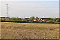
Farmland south-west of Castlecroft, Wolverhampton
The housing cluster is by Langlade Farm, seen by looking west from Langley Road.
Image: © Roger Kidd
Taken: 30 Oct 2019
0.05 miles
2

Yellow Pylon
The view from the Staffordshire footpath near Langley Road.
Image: © Gordon Griffiths
Taken: 8 May 2015
0.06 miles
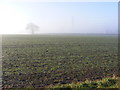
3
Misty Skyline
The view from the field edge path from Langley Road in Lower Penn.
Image: © Gordon Griffiths
Taken: 29 Dec 2016
0.09 miles
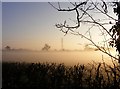
4
Tree in the Mist
The view of the field from the Langley Road path in Lower Penn.
Image: © Gordon Griffiths
Taken: 29 Dec 2016
0.09 miles
5
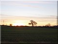
Langley Sunset
The view near Langley Road in Lower Penn, Staffordshire.
Image: © Gordon Griffiths
Taken: 9 Jan 2019
0.12 miles
6
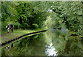
Staffordshire and Worcestershire Canal near Lower Penn, Staffordshire
Looking north towards Castlecroft and Wolverhampton (Compton).
Image: © Roger D Kidd
Taken: 25 Aug 2017
0.13 miles
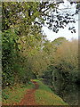
7
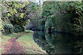
Canal and towpath near Lower Penn in Staffordshire
Looking north towards Wolverhampton, this is the Staffordshire and Worcestershire Canal north-west of Lower Penn in Staffordshire. This is about five hundred metres north of Dimmingsdale Bridge. Off to the left are substantial pools used for angling.
Image: © Roger Kidd
Taken: 30 Oct 2019
0.13 miles
8
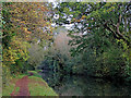
Canal north-west of Lower Penn in Staffordshire
Looking north towards Wolverhampton, this is the Staffordshire and Worcestershire Canal north-west of Lower Penn in Staffordshire. This is about four hundred metres north of Dimmingsdale Bridge. Off to the left are substantial pools used for angling.
Image: © Roger Kidd
Taken: 30 Oct 2019
0.13 miles
9
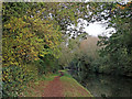
Canal north-west of Lower Penn in Staffordshire
Looking north towards Wolverhampton, this is the Staffordshire and Worcestershire Canal north-west of Lower Penn in Staffordshire. This is about four hundred metres north of Dimmingsdale Bridge. Off to the left are substantial pools used for angling.
Image: © Roger Kidd
Taken: 30 Oct 2019
0.13 miles
10
Canal north-west of Lower Penn in Staffordshire
Looking north towards Wolverhampton, this is the Staffordshire and Worcestershire Canal north-west of Lower Penn in Staffordshire. This is about four hundred metres north of Dimmingsdale Bridge. Off to the left are substantial pools used for angling.
Image: © Roger Kidd
Taken: 30 Oct 2019
0.13 miles