IMAGES TAKEN NEAR TO
Dirty Foot Lane, WOLVERHAMPTON, WV4 4UY
Introduction
This page details the photographs taken nearby to Dirty Foot Lane, WV4 4UY by members of the Geograph project.
The Geograph project started in 2005 with the aim of publishing, organising and preserving representative images for every square kilometre of Great Britain, Ireland and the Isle of Man.

There are currently over 7.5m images from over14,400 individuals and you can help contribute to the project by visiting https://www.geograph.org.uk
Image Map
Images are licensed for reuse under creativecommons.org/licenses/by-sa/2.0
Notes
- Clicking on the map will re-center to the selected point.
- The higher the marker number, the further away the image location is from the centre of the postcode.
Image Listing (46 Images Found)
Images are licensed for reuse under creativecommons.org/licenses/by-sa/2.0
Image
Details
Distance
1
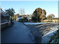
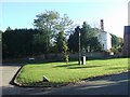
Village Green, Lower Penn
Compare this with the rather less arctic view in Image - recognisably the same place, albeit from a slightly different view direction.
Image: © Richard Law
Taken: 8 Dec 2010
0.02 miles
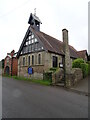
2
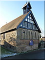
Church Bench
The view of St. Anne's Church from Dirtyfoot Lane in Lower Penn.
Image: © Gordon Griffiths
Taken: 26 Mar 2018
0.02 miles
3
Church Scene
The view of St Anne's Church in Springhill Lane in Lower Penn.
Image: © Gordon Griffiths
Taken: 15 Jul 2020
0.03 miles
4
The Village Green, Lower Penn
Charlton House overlooks the village green. Dirtyfoot Lane leads off to the left towards Westcroft Farm.
Image: © John M
Taken: 18 Nov 2006
0.04 miles
5
Church Scene
The view of St. Anne's Church on Springhill Lane in Lower Penn.
The view in Nov 2006 Image
Image: © Gordon Griffiths
Taken: 20 May 2021
0.04 miles
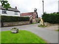
6
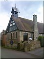
St. Anne's Church
The view from Springhill Lane of St. Anne's Church in Lower Penn.
Image: © Gordon Griffiths
Taken: 26 Mar 2018
0.04 miles
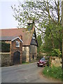
7
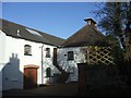
The Malthouse
On the opposite side of the road to the church in Lower Penn.
Image: © John M
Taken: 18 Nov 2006
0.05 miles
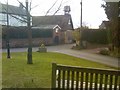
8
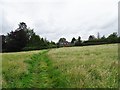
Lower Penn Path
The view of the footpath from Showell Lane in Lower Penn, Staffordshire.
Image: © Gordon Griffiths
Taken: 15 Jul 2020
0.05 miles
9
Dirtyfoot Lane Junction
The Lane joins Springhill Lane near St. Anne's Church Lower Penn.
Image: © Gordon Griffiths
Taken: 25 Jun 2006
0.06 miles