IMAGES TAKEN NEAR TO
Rutland Avenue, WOLVERHAMPTON, WV4 4JA
Introduction
This page details the photographs taken nearby to Rutland Avenue, WV4 4JA by members of the Geograph project.
The Geograph project started in 2005 with the aim of publishing, organising and preserving representative images for every square kilometre of Great Britain, Ireland and the Isle of Man.

There are currently over 7.5m images from over14,400 individuals and you can help contribute to the project by visiting https://www.geograph.org.uk
Image Map (Loading...)


Getting Data...Please wait
Leaflet Map data © OpenStreetMap
Images are licensed for reuse under creativecommons.org/licenses/by-sa/2.0
Notes
- Clicking on the map will re-center to the selected point.
- The higher the marker number, the further away the image location is from the centre of the postcode.
Image Listing (37 Images Found)
Images are licensed for reuse under creativecommons.org/licenses/by-sa/2.0
Image
Details
Distance
1
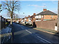
Wynchcombe Avenue, Penn
The small church marked part way up the road (not the main Image) no longer seems to exist, unless it's heavily disguised as a pair of semis.
Image: © Richard Law
Taken: 9 Dec 2010
0.08 miles
2
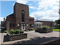
Springdale Church
The view of the Methodist Church in Warstones Road, Lower Penn, Wolverhampton.
Image: © Gordon Griffiths
Taken: 18 Aug 2013
0.12 miles
3
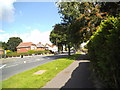
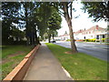
Warstones Road View
The view from Wynchcombe Avenue in Lower Penn, Wolverhampton.
Image: © Gordon Griffiths
Taken: 17 Aug 2013
0.12 miles
4
Hollybush Lane Scene
The view in Spring Hill, Wolverhampton.
Image: © Gordon Griffiths
Taken: 20 Dec 2021
0.12 miles
5
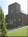
Springdale Church
A Methodist Church on Warstones Road.
Image: © Gordon Griffiths
Taken: 10 May 2007
0.13 miles
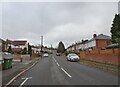
6
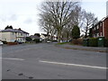
Warstones Road
The view in Lower Penn, Wolverhampton.
Image: © Gordon Griffiths
Taken: 17 Aug 2013
0.14 miles
7
Hollybush Lane View
The view along Warstones Road in Spring Hill, Wolverhampton.
Image: © Gordon Griffiths
Taken: 9 Mar 2021
0.15 miles
8
Scott Avenue, Penn
1950s(?) semis in Scott Avenue, photographed from Lytton Avenue.
Image: © Richard Law
Taken: 9 Dec 2010
0.16 miles
9
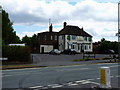
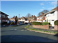
The Warstones
A public house on Warstones Road.
Image: © Richard Law
Taken: 5 Jul 2010
0.17 miles
10
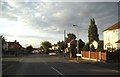
Hollybush Lane Crossroads
The view of the junction with Braden Road in Spring Hill, Wolverhampton
Image: © Gordon Griffiths
Taken: 11 Aug 2015
0.18 miles