IMAGES TAKEN NEAR TO
Walden Gardens, WOLVERHAMPTON, WV4 4EY
Introduction
This page details the photographs taken nearby to Walden Gardens, WV4 4EY by members of the Geograph project.
The Geograph project started in 2005 with the aim of publishing, organising and preserving representative images for every square kilometre of Great Britain, Ireland and the Isle of Man.

There are currently over 7.5m images from over14,400 individuals and you can help contribute to the project by visiting https://www.geograph.org.uk
Image Map
Images are licensed for reuse under creativecommons.org/licenses/by-sa/2.0
Notes
- Clicking on the map will re-center to the selected point.
- The higher the marker number, the further away the image location is from the centre of the postcode.
Image Listing (58 Images Found)
Images are licensed for reuse under creativecommons.org/licenses/by-sa/2.0
Image
Details
Distance
1
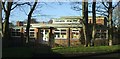
Warstones Primary School
Classrooms and exit at the back of the school.
Image: © John M
Taken: 2 Dec 2006
0.06 miles
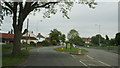
2
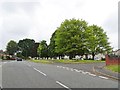
Pinfold Crescent
The view in Lower Penn, Wolverhampton.
Image: © Gordon Griffiths
Taken: 13 Jul 2019
0.09 miles
3
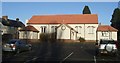
St Michaels Church Hall, Merry Hill
This would have been the old church prior to the new building Image
Image: © John M
Taken: 2 Dec 2006
0.12 miles
4
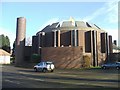
St Michaels RC Church, Merry Hill
A large church on Coalway Road.
Image: © John M
Taken: 2 Dec 2006
0.12 miles
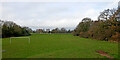
5

Football training on the Recreation Ground
A busy Saturday morning at the recreation ground off Pinfold Lane.
Image: © John M
Taken: 2 Dec 2006
0.13 miles
7
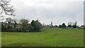
Windsor Avenue Playing Fields in Penn, Wolverhampton
Looking south-west towards Mason Crescent (on the left) and Pinfold Lane (ahead).
This image was taken at 12:00 GMT (UTC) on Christmas Day in 2022. Plenty of dog-walkers were about, but no footballers.
Five full sized football pitches are available, plus one junior sized pitch.
Cloudy and bright with occasional shafts of sunlight.
Wind south-south-west Force 2-3
Temperature 9·5°C
Image: © Roger Kidd
Taken: 25 Dec 2022
0.14 miles
8
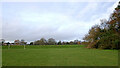
Playing fields in Penn, Wolverhampton
Windsor Avenue Playing Fields, looking north-west towards the embankment and the upper level pitches.
There are five full size football pitches, and a further junior size pitch. Changing rooms, and parking for about fifty cars are by the Pinfold Lane entrance. There are also some areas of woodland, and a children's play area near the Linton Road entrance.
This Christmas Day 2022 image was taken shortly after midday.
Image: © Roger Kidd
Taken: 25 Dec 2022
0.14 miles
9
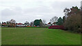
Windsor Avenue Playing Fields in Penn Wolverhampton
Looking north-east towards Windsor Avenue.
There are five full size football pitches, and a further junior size pitch. Changing rooms, and parking for about fifty cars are by the Pinfold Lane entrance. There are also some areas of woodland with some very mature trees, and a children's playground near the Linton Road entrance.
This Christmas Day 2022 image was taken shortly before midday.
Image: © Roger Kidd
Taken: 25 Dec 2022
0.15 miles
10
Playing fields in Penn, Wolverhampton
Windsor Avenue Playing Fields, looking north-west towards Warstones from near the children's play area.
There are five full size football pitches, and a further junior size pitch. Changing rooms, and parking for about fifty cars are by the Pinfold Lane entrance. There are also some areas of woodland with some very mature trees, and a children's play area near the Linton Road entrance.
The boomerang shaped mound in the foreground resembles some errant glacial deposit, ideal for rolling down the sides on a warmer and drier day than today. This Christmas Day 2022 image was taken shortly after midday.
Image: © Roger Kidd
Taken: 25 Dec 2022
0.15 miles